Zhaoxian geodata
Zhaoxian (Jiangxi) is a seat of a third-order administrative division; located in China in Asia/Shanghai (GMT+8) time zone. In our database, there are 1268 cities with bigger population. Compared to other cities in China, 67.8% of cities are located further ↑North; 58.4% of cities are located further ←West and 73% of cities have higher elevation than Zhaoxian. Note1


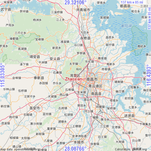
Zhaoxian GPS coordinates[2]
28° 42' 22.248" North, 115° 44' 10.212" East
| Map corner | latitude | longitude |
|---|---|---|
| Upper-left | 29.32106°, | 115.03305° |
| Center: | 28.70618°, | 115.73617° |
| Lower-right: | 28.08766°, | 116.4393° |
| Map W x H: | 137.1×137.1 km | = 85.2×85.2mi |
| max Lat: | 53.31946° ⇑67.8% North |
| Zhaoxian: | 28.70618° |
| min Lat: | ⇓32.2% South 18.22056° |
| min Long | Zhaoxian | max Long |
| 75.07348° | 115.73617° | 134.28917° |
| W 58.4%⇐ | ⇒41.6% E |
Elevation
Elevation of Zhaoxian is 42 m = 138 ft, and this is 442.8 m = 1453 ft below average elevation for this country.
| Max E: |
5622 m = 18445 ft | 73% |
| Avg. | 484.8 m = 1591 ft | |
| Zhaoxian | 42 m = 138 ft | |
Min E: |
-3 m = -10 ft | 27% |
See also: China elevation on elevation.city.
Geographical zone
Zhaoxian is located in North temperate zone (between Tropic of Cancer and the Arctic Circle). Distance of this Northern Tropic circle is 585.9 km =364.1 mi to South.| Distance of | km | miles | from Zhaoxian |
|---|---|---|---|
| North Pole | 6815.2 | 4234.8 | to North |
| Arctic Circle | 4209.3 | 2615.5 | to North |
| Tropic Cancer | 585.9 | 364.1 | to South |
| Equator | 3191.8 | 1983.3 | to South |


Nearby cities:
15 places around Zhaoxian: (largest is in red/bold)
• Changbu
14.7 km =9.1 mi,  312°
312°
• Changjun
17.9 km =11.1 mi,  353°
353°
• Changleng
7.9 km =4.9 mi,  95°
95°
• Dongxin
15.8 km =9.8 mi,  145°
145°
• Jiaoqiao
12.7 km =7.9 mi,  69°
69°
• Lehua
17.9 km =11.1 mi,  44°
44°
• Meiling
9.6 km =6 mi,  5°
5°
• Nanchang
11.7 km =7.3 mi, 102°
• Qiaole
18.2 km =11.3 mi,  247°
247°
• Shengmi
15.8 km =9.8 mi,  159°
159°
• Shibi
16.5 km =10.3 mi,  279°
279°
• Taiping
11.2 km =7 mi, 348°
• Taohua
14.6 km =9.1 mi,  113°
113°
• Wangcheng
5.7 km =3.5 mi,  129°
129°
• Yangzizhou
16.7 km =10.4 mi,  83°
83°
Sources, notices
• [Note1] Compared only with cities in China existing in our database
• [Src1] Map data: © OpenStreetMap contributors (CC-BY-SA)
• [Src2] Other city data from geonames.org with taken over terms of usage.
• [Src3] Geographical zone / Annual Mean Temperature by Robert A. Rohde @ Wikipedia
