Wangcheng geodata
Wangcheng (Jiangxi) is a seat of a fourth-order administrative division; located in China in Asia/Shanghai (GMT+8) time zone. In our database, there are 1268 cities with bigger population. Compared to other cities in China, 68.2% of cities are located further ↑North; 58.7% of cities are located further ←West and 71.6% of cities have higher elevation than Wangcheng. Note1


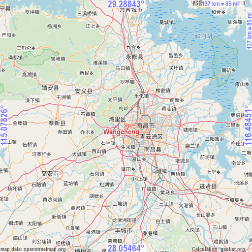
Wangcheng GPS coordinates[2]
28° 40' 24.06" North, 115° 46' 52.968" East
| Map corner | latitude | longitude |
|---|---|---|
| Upper-left | 29.28843°, | 115.07826° |
| Center: | 28.67335°, | 115.78138° |
| Lower-right: | 28.05464°, | 116.48451° |
| Map W x H: | 137.2×137.2 km | = 85.3×85.3mi |
| max Lat: | 53.31946° ⇑68.2% North |
| Wangcheng: | 28.67335° |
| min Lat: | ⇓31.8% South 18.22056° |
| min Long | Wangcheng | max Long |
| 75.07348° | 115.78138° | 134.28917° |
| W 58.7%⇐ | ⇒41.3% E |
Elevation
Elevation of Wangcheng is 46 m = 151 ft, and this is 438.8 m = 1440 ft below average elevation for this country.
| Max E: |
5622 m = 18445 ft | 71.6% |
| Avg. | 484.8 m = 1591 ft | |
| Wangcheng | 46 m = 151 ft | |
Min E: |
-3 m = -10 ft | 28.4% |
See also: China elevation on elevation.city.
Geographical zone
Wangcheng is located in North temperate zone (between Tropic of Cancer and the Arctic Circle). Distance of this Northern Tropic circle is 582.3 km =361.8 mi to South.| Distance of | km | miles | from Wangcheng |
|---|---|---|---|
| North Pole | 6818.9 | 4237.1 | to North |
| Arctic Circle | 4213 | 2617.8 | to North |
| Tropic Cancer | 582.3 | 361.8 | to South |
| Equator | 3188.2 | 1981.1 | to South |


Nearby cities:
15 places around Wangcheng: (largest is in red/bold)
• Changbu
20.5 km =12.7 mi,  311°
311°
• Changleng
4.5 km =2.8 mi,  49°
49°
• Dongxin
10.4 km =6.5 mi,  154°
154°
• Fushan
18.9 km =11.7 mi,  158°
158°
• Jiaoqiao
11 km =6.8 mi,  43°
43°
• Lehua
18.3 km =11.4 mi,  26°
26°
• Meiling
13.7 km =8.5 mi,  344°
344°
• Nanchang
7.1 km =4.4 mi,  80°
80°
• Shengmi
11.2 km =7 mi,  174°
174°
• Taiping
16 km =9.9 mi, 335°
• Taohua
9.2 km =5.7 mi,  103°
103°
• Xishan
20.4 km =12.7 mi,  228°
228°
• Xixia
21.5 km =13.4 mi,  16°
16°
• Yangzizhou
13.3 km =8.3 mi,  65°
65°
• Zhaoxian
5.7 km =3.5 mi, 309°
Sources, notices
• [Note1] Compared only with cities in China existing in our database
• [Src1] Map data: © OpenStreetMap contributors (CC-BY-SA)
• [Src2] Other city data from geonames.org with taken over terms of usage.
• [Src3] Geographical zone / Annual Mean Temperature by Robert A. Rohde @ Wikipedia
