Nanchang geodata
Nanchang (Jiangxi) is a seat of a first-order administrative division; located in China in Asia/Shanghai (GMT+8) time zone. With population of 2,357,839 people, there are 41 cities with bigger population in this country. Compared to other cities in China, 68.1% of cities are located further ↑North; 59.2% of cities are located further ←West and 82.9% of cities have higher elevation than Nanchang. Note1


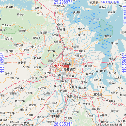
Nanchang GPS coordinates[2]
28° 41' 2.256" North, 115° 51' 11.016" East
| Map corner | latitude | longitude |
|---|---|---|
| Upper-left | 29.29897°, | 115.14994° |
| Center: | 28.68396°, | 115.85306° |
| Lower-right: | 28.06531°, | 116.55619° |
| Map W x H: | 137.2×137.2 km | = 85.3×85.3mi |
| max Lat: | 53.31946° ⇑68.1% North |
| Nanchang: | 28.68396° |
| min Lat: | ⇓31.9% South 18.22056° |
| min Long | Nanchang | max Long |
| 75.07348° | 115.85306° | 134.28917° |
| W 59.2%⇐ | ⇒40.8% E |
Elevation
Elevation of Nanchang is 20 m = 66 ft, and this is 464.8 m = 1525 ft below average elevation for this country.
| Max E: |
5622 m = 18445 ft | 82.9% |
| Avg. | 484.8 m = 1591 ft | |
| Nanchang | 20 m = 66 ft | |
Min E: |
-3 m = -10 ft | 17.1% |
See also: Nanchang elevation on elevation.city.
Geographical zone
Nanchang is located in North temperate zone (between Tropic of Cancer and the Arctic Circle). Distance of this Northern Tropic circle is 583.4 km =362.5 mi to South.| Distance of | km | miles | from Nanchang |
|---|---|---|---|
| North Pole | 6817.7 | 4236.3 | to North |
| Arctic Circle | 4211.8 | 2617.1 | to North |
| Tropic Cancer | 583.4 | 362.5 | to South |
| Equator | 3189.4 | 1981.8 | to South |


Nearby cities:
15 places around Nanchang: (largest is in red/bold)
• Changleng
4 km =2.5 mi,  296°
296°
• Dongxin
10.8 km =6.7 mi,  193°
193°
• Fushan
18.7 km =11.6 mi,  179°
179°
• Jiangxiangzhen
18.1 km =11.2 mi,  61°
61°
• Jiaoqiao
6.9 km =4.3 mi,  4°
4°
• Lehua
15.3 km =9.5 mi, 4°
• Maqiu
22 km =13.7 mi,  93°
93°
• Meiling
16 km =9.9 mi,  318°
318°
• Shengmi
13.7 km =8.5 mi,  205°
205°
• Taiping
19.1 km =11.9 mi,  314°
314°
• Taohua
3.9 km =2.4 mi,  150°
150°
• Wangcheng
7.1 km =4.4 mi,  260°
260°
• Xixia
19.4 km =12.1 mi,  357°
357°
• Yangzizhou
6.7 km =4.2 mi,  50°
50°
• Zhaoxian
11.7 km =7.3 mi,  282°
282°
Sources, notices
• [Note1] Compared only with cities in China existing in our database
• [Src1] Map data: © OpenStreetMap contributors (CC-BY-SA)
• [Src2] Other city data from geonames.org with taken over terms of usage.
• [Src3] Geographical zone / Annual Mean Temperature by Robert A. Rohde @ Wikipedia
