Houtian geodata
Houtian (Jiangxi) is a seat of a fourth-order administrative division; located in China in Asia/Shanghai (GMT+8) time zone. In our database, there are 1268 cities with bigger population. Compared to other cities in China, 70% of cities are located further ↑North; 58.8% of cities are located further ←West and 74.8% of cities have higher elevation than Houtian. Note1


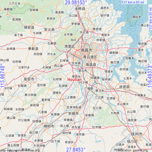
Houtian GPS coordinates[2]
28° 27' 54.792" North, 115° 47' 26.16" East
| Map corner | latitude | longitude |
|---|---|---|
| Upper-left | 29.08153°, | 115.08748° |
| Center: | 28.46522°, | 115.7906° |
| Lower-right: | 27.8453°, | 116.49373° |
| Map W x H: | 137.5×137.5 km | = 85.4×85.4mi |
| max Lat: | 53.31946° ⇑70% North |
| Houtian: | 28.46522° |
| min Lat: | ⇓30% South 18.22056° |
| min Long | Houtian | max Long |
| 75.07348° | 115.7906° | 134.28917° |
| W 58.8%⇐ | ⇒41.2% E |
Elevation
Elevation of Houtian is 37 m = 121 ft, and this is 447.8 m = 1469 ft below average elevation for this country.
| Max E: |
5622 m = 18445 ft | 74.8% |
| Avg. | 484.8 m = 1591 ft | |
| Houtian | 37 m = 121 ft | |
Min E: |
-3 m = -10 ft | 25.2% |
See also: China elevation on elevation.city.
Geographical zone
Houtian is located in North temperate zone (between Tropic of Cancer and the Arctic Circle). Distance of this Northern Tropic circle is 559.1 km =347.4 mi to South.| Distance of | km | miles | from Houtian |
|---|---|---|---|
| North Pole | 6842 | 4251.4 | to North |
| Arctic Circle | 4236.1 | 2632.2 | to North |
| Tropic Cancer | 559.1 | 347.4 | to South |
| Equator | 3165 | 1966.6 | to South |


Nearby cities:
15 places around Houtian: (largest is in red/bold)
• Dongxin
14.3 km =8.9 mi,  14°
14°
• Fushan
8.3 km =5.2 mi,  47°
47°
• Gangshang
8.9 km =5.5 mi,  126°
126°
• Hutang
23.5 km =14.6 mi,  227°
227°
• Liuhu
6.7 km =4.2 mi,  274°
274°
• Shangtang
20.1 km =12.5 mi,  196°
196°
• Shengmi
12 km =7.5 mi,  0°
0°
• Shigang
16.3 km =10.1 mi,  261°
261°
• Songhu
16.7 km =10.4 mi,  235°
235°
• Taohua
22.4 km =13.9 mi,  21°
21°
• Tongtianxiang
15 km =9.3 mi,  172°
172°
• Wangcheng
23.2 km =14.4 mi,  357°
357°
• Wuyang
22.3 km =13.9 mi,  74°
74°
• Xiangtang
17.4 km =10.8 mi,  104°
104°
• Xishan
18.8 km =11.7 mi,  300°
300°
Sources, notices
• [Note1] Compared only with cities in China existing in our database
• [Src1] Map data: © OpenStreetMap contributors (CC-BY-SA)
• [Src2] Other city data from geonames.org with taken over terms of usage.
• [Src3] Geographical zone / Annual Mean Temperature by Robert A. Rohde @ Wikipedia
