Shaowa geodata
Shaowa (Gansu) is a seat of a fourth-order administrative division; located in China in Asia/Shanghai (GMT+8) time zone. In our database, there are 1268 cities with bigger population. Compared to other cities in China, 74.9% of cities are located further ↓South; 90.9% of cities are located further →East and 96.3% of cities have lower elevation than Shaowa. Note1


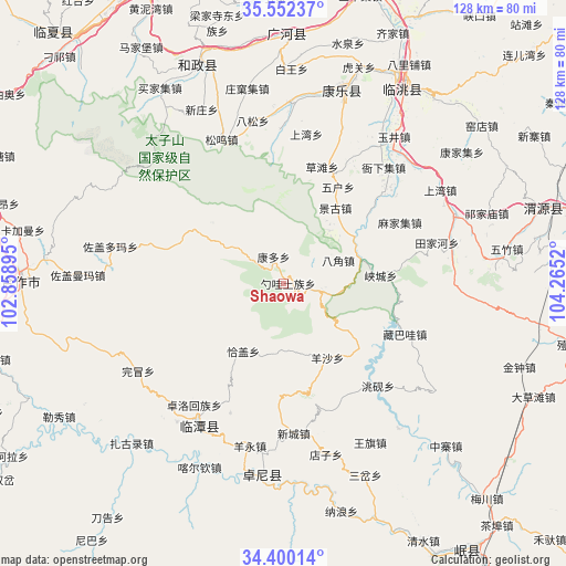
Shaowa GPS coordinates[2]
34° 58' 41.808" North, 103° 33' 43.452" East
| Map corner | latitude | longitude |
|---|---|---|
| Upper-left | 35.55237°, | 102.85895° |
| Center: | 34.97828°, | 103.56207° |
| Lower-right: | 34.40014°, | 104.2652° |
| Map W x H: | 128.1×128.1 km | = 79.6×79.6mi |
| max Lat: | 53.31946° ⇑25.1% North |
| Shaowa: | 34.97828° |
| min Lat: | ⇓74.9% South 18.22056° |
| min Long | Shaowa | max Long |
| 75.07348° | 103.56207° | 134.28917° |
| W 9.1%⇐ | ⇒90.9% E |
Elevation
Elevation of Shaowa is 2743 m = 8999 ft, and this is 2258.2 m = 7409 ft above average elevation for this country.
| Max E: |
5622 m = 18445 ft | 3.7% |
| Shaowa | 2743 m 8999 ft | |
| Avg. | 484.8 m = 1591 ft | |
Min E: |
-3 m = -10 ft | 96.3% |
See also: China elevation on elevation.city.
Geographical zone
Shaowa is located in North temperate zone (between Tropic of Cancer and the Arctic Circle). Distance of this Northern Tropic circle is 1283.3 km =797.4 mi to South.| Distance of | km | miles | from Shaowa |
|---|---|---|---|
| North Pole | 6117.8 | 3801.4 | to North |
| Arctic Circle | 3512 | 2182.3 | to North |
| Tropic Cancer | 1283.3 | 797.4 | to South |
| Equator | 3889.2 | 2416.6 | to South |


Nearby cities:
15 places around Shaowa: (largest is in red/bold)
• Bajiao
13.5 km =8.4 mi,  65°
65°
• Biandu
36.4 km =22.6 mi,  168°
168°
• Changchuan
31.6 km =19.6 mi,  202°
202°
• Kangduo
7.1 km =4.4 mi,  331°
331°
• Lianlu
17.2 km =10.7 mi,  76°
76°
• Qiagai
17.5 km =10.9 mi,  212°
212°
• Shencang
31.8 km =19.8 mi, 211°
• Shimen
29.8 km =18.5 mi,  154°
154°
• Tianjiahe
35.8 km =22.2 mi, 74°
• Xiacheng
22 km =13.7 mi, 84°
• Xincheng
33.9 km =21.1 mi,  176°
176°
• Yangsha
19 km =11.8 mi, 149°
• Yeliguan
9.1 km =5.7 mi,  99°
99°
• Zangbawa
29.5 km =18.3 mi,  112°
112°
• Zhuolu
34.1 km =21.2 mi,  216°
216°
Sources, notices
• [Note1] Compared only with cities in China existing in our database
• [Src1] Map data: © OpenStreetMap contributors (CC-BY-SA)
• [Src2] Other city data from geonames.org with taken over terms of usage.
• [Src3] Geographical zone / Annual Mean Temperature by Robert A. Rohde @ Wikipedia
