Sanbao geodata
Sanbao (Heilongjiang) is a seat of a fourth-order administrative division; located in China in Asia/Shanghai (GMT+8) time zone. In our database, there are 1268 cities with bigger population. Compared to other cities in China, 94.7% of cities are located further ↓South; 97.7% of cities are located further ←West and 50.2% of cities have lower elevation than Sanbao. Note1


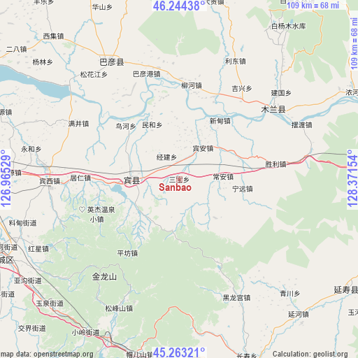
Sanbao GPS coordinates[2]
45° 45' 21.42" North, 127° 40' 6.276" East
| Map corner | latitude | longitude |
|---|---|---|
| Upper-left | 46.24438°, | 126.96529° |
| Center: | 45.75595°, | 127.66841° |
| Lower-right: | 45.26321°, | 128.37154° |
| Map W x H: | 109.1×109.1 km | = 67.8×67.8mi |
| max Lat: | 53.31946° ⇑5.3% North |
| Sanbao: | 45.75595° |
| min Lat: | ⇓94.7% South 18.22056° |
| min Long | Sanbao | max Long |
| 75.07348° | 127.66841° | 134.28917° |
| W 97.7%⇐ | ⇒2.3% E |
Elevation
Elevation of Sanbao is 167 m = 548 ft, and this is 317.8 m = 1043 ft below average elevation for this country.
| Max E: |
5622 m = 18445 ft | 49.8% |
| Avg. | 484.8 m = 1591 ft | |
| Sanbao | 167 m = 548 ft | |
Min E: |
-3 m = -10 ft | 50.2% |
See also: China elevation on elevation.city.
Geographical zone
Sanbao is located in North temperate zone (between Tropic of Cancer and the Arctic Circle). Distance of this North polar circle is 2313.6 km =1437.6 mi to North.| Distance of | km | miles | from Sanbao |
|---|---|---|---|
| North Pole | 4919.5 | 3056.8 | to North |
| Arctic Circle | 2313.6 | 1437.6 | to North |
| Tropic Cancer | 2481.7 | 1542.1 | to South |
| Equator | 5087.6 | 3161.3 | to South |


Nearby cities:
15 places around Sanbao: (largest is in red/bold)
• Bayangang
33.4 km =20.8 mi,  342°
342°
• Binzhou
14.6 km =9.1 mi,  268°
268°
• Bin’an
11.9 km =7.4 mi,  36°
36°
• Chang’an
13.2 km =8.2 mi,  86°
86°
• Guang’en
16.6 km =10.3 mi,  136°
136°
• Jingjian
7.7 km =4.8 mi,  332°
332°
• Jixing
33.6 km =20.9 mi,  34°
34°
• Juren
30.2 km =18.8 mi, 271°
• Liuhe
28.7 km =17.8 mi,  7°
7°
• Minhe
18.6 km =11.6 mi, 333°
• Niaohe
23 km =14.3 mi,  314°
314°
• Ningyuan
19.4 km =12.1 mi,  98°
98°
• Pingfang
27.5 km =17.1 mi,  215°
215°
• Shengli
30 km =18.6 mi,  80°
80°
• Xindian
21.8 km =13.5 mi, 34°
Sources, notices
• [Note1] Compared only with cities in China existing in our database
• [Src1] Map data: © OpenStreetMap contributors (CC-BY-SA)
• [Src2] Other city data from geonames.org with taken over terms of usage.
• [Src3] Geographical zone / Annual Mean Temperature by Robert A. Rohde @ Wikipedia
