Qihong geodata
Qihong (Anhui) is a seat of a fourth-order administrative division; located in China in Asia/Shanghai (GMT+8) time zone. In our database, there are 1268 cities with bigger population. Compared to other cities in China, 57.5% of cities are located further ↑North; 69.4% of cities are located further ←West and 62.7% of cities have lower elevation than Qihong. Note1


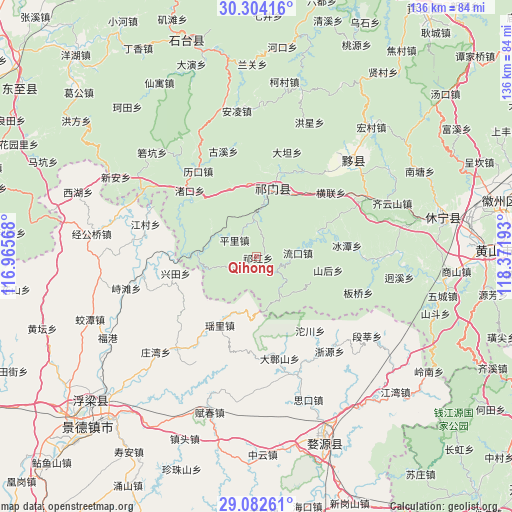
Qihong GPS coordinates[2]
29° 41' 42.864" North, 117° 40' 7.68" East
| Map corner | latitude | longitude |
|---|---|---|
| Upper-left | 30.30416°, | 116.96568° |
| Center: | 29.69524°, | 117.6688° |
| Lower-right: | 29.08261°, | 118.37193° |
| Map W x H: | 135.8×135.8 km | = 84.4×84.4mi |
| max Lat: | 53.31946° ⇑57.5% North |
| Qihong: | 29.69524° |
| min Lat: | ⇓42.5% South 18.22056° |
| min Long | Qihong | max Long |
| 75.07348° | 117.6688° | 134.28917° |
| W 69.4%⇐ | ⇒30.6% E |
Elevation
Elevation of Qihong is 292 m = 958 ft, and this is 192.8 m = 633 ft below average elevation for this country.
| Max E: |
5622 m = 18445 ft | 37.3% |
| Avg. | 484.8 m = 1591 ft | |
| Qihong | 292 m = 958 ft | |
Min E: |
-3 m = -10 ft | 62.7% |
See also: China elevation on elevation.city.
Geographical zone
Qihong is located in North temperate zone (between Tropic of Cancer and the Arctic Circle). Distance of this Northern Tropic circle is 695.9 km =432.4 mi to South.| Distance of | km | miles | from Qihong |
|---|---|---|---|
| North Pole | 6705.3 | 4166.5 | to North |
| Arctic Circle | 4099.4 | 2547.2 | to North |
| Tropic Cancer | 695.9 | 432.4 | to South |
| Equator | 3301.8 | 2051.6 | to South |


Nearby cities:
15 places around Qihong: (largest is in red/bold)
• Dengta
19.3 km =12 mi,  359°
359°
• Hecheng
6.4 km =4 mi,  131°
131°
• Jinzipai
21.5 km =13.4 mi,  38°
38°
• Liukou
11 km =6.8 mi,  84°
84°
• Luxi
15.7 km =9.8 mi,  274°
274°
• Pingli
7.4 km =4.6 mi,  308°
308°
• Qiaoshan
9.1 km =5.7 mi,  32°
32°
• Qishan
17.3 km =10.7 mi,  16°
16°
• Rongkou
13.5 km =8.4 mi,  294°
294°
• Shanhou
19.2 km =11.9 mi,  101°
101°
• Tafang
9.5 km =5.9 mi, 357°
• Wangcun
15.1 km =9.4 mi,  119°
119°
• Xiaolukou
19.4 km =12.1 mi,  342°
342°
• Xuling
22.6 km =14 mi,  13°
13°
• Yaoli
18.9 km =11.7 mi,  208°
208°
Sources, notices
• [Note1] Compared only with cities in China existing in our database
• [Src1] Map data: © OpenStreetMap contributors (CC-BY-SA)
• [Src2] Other city data from geonames.org with taken over terms of usage.
• [Src3] Geographical zone / Annual Mean Temperature by Robert A. Rohde @ Wikipedia
