Shazhou geodata
Shazhou (Jiangxi) is a seat of a fourth-order administrative division; located in China in Asia/Shanghai (GMT+8) time zone. In our database, there are 1268 cities with bigger population. Compared to other cities in China, 75.5% of cities are located further ↑North; 65.1% of cities are located further ←West and 60.6% of cities have higher elevation than Shazhou. Note1


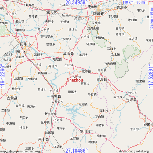
Shazhou GPS coordinates[2]
27° 43' 44.4" North, 116° 49' 32.808" East
| Map corner | latitude | longitude |
|---|---|---|
| Upper-left | 28.34959°, | 116.12266° |
| Center: | 27.729°, | 116.82578° |
| Lower-right: | 27.10486°, | 117.52891° |
| Map W x H: | 138.4×138.4 km | = 86×86mi |
| max Lat: | 53.31946° ⇑75.5% North |
| Shazhou: | 27.729° |
| min Lat: | ⇓24.5% South 18.22056° |
| min Long | Shazhou | max Long |
| 75.07348° | 116.82578° | 134.28917° |
| W 65.1%⇐ | ⇒34.9% E |
Elevation
Elevation of Shazhou is 95 m = 312 ft, and this is 389.8 m = 1279 ft below average elevation for this country.
| Max E: |
5622 m = 18445 ft | 60.6% |
| Avg. | 484.8 m = 1591 ft | |
| Shazhou | 95 m = 312 ft | |
Min E: |
-3 m = -10 ft | 39.4% |
See also: China elevation on elevation.city.
Geographical zone
Shazhou is located in North temperate zone (between Tropic of Cancer and the Arctic Circle). Distance of this Northern Tropic circle is 477.3 km =296.6 mi to South.| Distance of | km | miles | from Shazhou |
|---|---|---|---|
| North Pole | 6923.9 | 4302.3 | to North |
| Arctic Circle | 4318 | 2683.1 | to North |
| Tropic Cancer | 477.3 | 296.6 | to South |
| Equator | 3083.2 | 1915.8 | to South |


Nearby cities:
15 places around Shazhou: (largest is in red/bold)
• Dengfang
31 km =19.3 mi,  287°
287°
• Gaotian
4.4 km =2.7 mi,  30°
30°
• Heyuan
32.1 km =19.9 mi,  22°
22°
• Hongmen
28.7 km =17.8 mi,  203°
203°
• Jianchang
26.4 km =16.4 mi,  223°
223°
• Lufang
31.3 km =19.4 mi,  359°
359°
• Shimen
17.4 km =10.8 mi, 288°
• Shixia
9.8 km =6.1 mi,  129°
129°
• Songshi
10.1 km =6.3 mi,  60°
60°
• Tengqiao
31.3 km =19.4 mi,  276°
276°
• Tianjingyuan
28.1 km =17.5 mi, 218°
• Wanfang
24.2 km =15 mi,  238°
238°
• Xiugu
20.8 km =12.9 mi,  346°
346°
• Xujia
16 km =9.9 mi, 236°
• Zuofang
12.8 km =8 mi,  324°
324°
Sources, notices
• [Note1] Compared only with cities in China existing in our database
• [Src1] Map data: © OpenStreetMap contributors (CC-BY-SA)
• [Src2] Other city data from geonames.org with taken over terms of usage.
• [Src3] Geographical zone / Annual Mean Temperature by Robert A. Rohde @ Wikipedia
