Bailing geodata
Bailing (Jiangxi) is a seat of a fourth-order administrative division; located in China in Asia/Shanghai (GMT+8) time zone. In our database, there are 1268 cities with bigger population. Compared to other cities in China, 64.5% of cities are located further ↑North; 51.2% of cities are located further →East and 62.9% of cities have lower elevation than Bailing. Note1


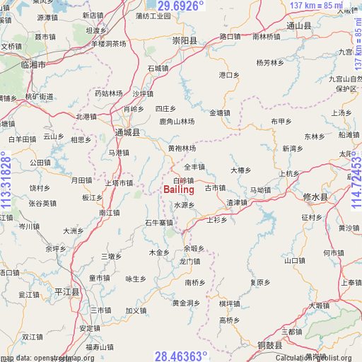
Bailing GPS coordinates[2]
29° 4' 47.82" North, 114° 1' 17.04" East
| Map corner | latitude | longitude |
|---|---|---|
| Upper-left | 29.6926°, | 113.31828° |
| Center: | 29.07995°, | 114.0214° |
| Lower-right: | 28.46363°, | 114.72453° |
| Map W x H: | 136.6×136.6 km | = 84.9×84.9mi |
| max Lat: | 53.31946° ⇑64.5% North |
| Bailing: | 29.07995° |
| min Lat: | ⇓35.5% South 18.22056° |
| min Long | Bailing | max Long |
| 75.07348° | 114.0214° | 134.28917° |
| W 48.8%⇐ | ⇒51.2% E |
Elevation
Elevation of Bailing is 295 m = 968 ft, and this is 189.8 m = 623 ft below average elevation for this country.
| Max E: |
5622 m = 18445 ft | 37.1% |
| Avg. | 484.8 m = 1591 ft | |
| Bailing | 295 m = 968 ft | |
Min E: |
-3 m = -10 ft | 62.9% |
See also: China elevation on elevation.city.
Geographical zone
Bailing is located in North temperate zone (between Tropic of Cancer and the Arctic Circle). Distance of this Northern Tropic circle is 627.5 km =389.9 mi to South.| Distance of | km | miles | from Bailing |
|---|---|---|---|
| North Pole | 6773.7 | 4209 | to North |
| Arctic Circle | 4167.8 | 2589.8 | to North |
| Tropic Cancer | 627.5 | 389.9 | to South |
| Equator | 3233.4 | 2009.1 | to South |


Nearby cities:
15 places around Bailing: (largest is in red/bold)
• Dachun
22.7 km =14.1 mi,  79°
79°
• Daqiao
15.8 km =9.8 mi,  147°
147°
• Donggang
25.5 km =15.8 mi,  128°
128°
• Gaojian
22.5 km =14 mi,  11°
11°
• Guandao
19.3 km =12 mi,  322°
322°
• Gushi
12.5 km =7.8 mi,  99°
99°
• Huanglong
5.9 km =3.7 mi,  170°
170°
• Lukou
6.5 km =4 mi,  89°
89°
• Maishi
11.9 km =7.4 mi,  328°
328°
• Quanfeng
7.2 km =4.5 mi,  41°
41°
• Shangshan
19.7 km =12.2 mi,  137°
137°
• Shi’ao
18.2 km =11.3 mi,  118°
118°
• Shuiyuan
9.1 km =5.7 mi, 171°
• Tanghu
15.3 km =9.5 mi,  345°
345°
• Zhajin
22.3 km =13.9 mi,  110°
110°
Sources, notices
• [Note1] Compared only with cities in China existing in our database
• [Src1] Map data: © OpenStreetMap contributors (CC-BY-SA)
• [Src2] Other city data from geonames.org with taken over terms of usage.
• [Src3] Geographical zone / Annual Mean Temperature by Robert A. Rohde @ Wikipedia
