Maishi geodata
Maishi (Hubei) is a seat of a fourth-order administrative division; located in China in Asia/Shanghai (GMT+8) time zone. In our database, there are 1268 cities with bigger population. Compared to other cities in China, 63.5% of cities are located further ↑North; 51.7% of cities are located further →East and 55.2% of cities have higher elevation than Maishi. Note1


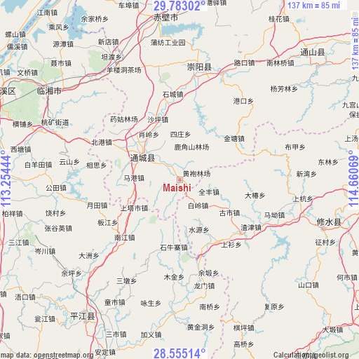
Maishi GPS coordinates[2]
29° 10' 15.312" North, 113° 57' 27.216" East
| Map corner | latitude | longitude |
|---|---|---|
| Upper-left | 29.78302°, | 113.25444° |
| Center: | 29.17092°, | 113.95756° |
| Lower-right: | 28.55514°, | 114.66069° |
| Map W x H: | 136.5×136.5 km | = 84.8×84.8mi |
| max Lat: | 53.31946° ⇑63.5% North |
| Maishi: | 29.17092° |
| min Lat: | ⇓36.5% South 18.22056° |
| min Long | Maishi | max Long |
| 75.07348° | 113.95756° | 134.28917° |
| W 48.3%⇐ | ⇒51.7% E |
Elevation
Elevation of Maishi is 130 m = 427 ft, and this is 354.8 m = 1164 ft below average elevation for this country.
| Max E: |
5622 m = 18445 ft | 55.2% |
| Avg. | 484.8 m = 1591 ft | |
| Maishi | 130 m = 427 ft | |
Min E: |
-3 m = -10 ft | 44.8% |
See also: China elevation on elevation.city.
Geographical zone
Maishi is located in North temperate zone (between Tropic of Cancer and the Arctic Circle). Distance of this Northern Tropic circle is 637.6 km =396.2 mi to South.| Distance of | km | miles | from Maishi |
|---|---|---|---|
| North Pole | 6763.6 | 4202.7 | to North |
| Arctic Circle | 4157.7 | 2583.5 | to North |
| Tropic Cancer | 637.6 | 396.2 | to South |
| Equator | 3243.5 | 2015.4 | to South |


Nearby cities:
15 places around Maishi: (largest is in red/bold)
• Bailing
11.9 km =7.4 mi,  148°
148°
• Gaojian
16.1 km =10 mi,  41°
41°
• Guandao
7.6 km =4.7 mi,  312°
312°
• Gushi
22.2 km =13.8 mi,  123°
123°
• Huanglong
17.4 km =10.8 mi,  155°
155°
• Juanshui
16.2 km =10.1 mi,  334°
334°
• Lukou
16.2 km =10.1 mi,  128°
128°
• Magang
17.9 km =11.1 mi,  274°
274°
• Quanfeng
11.9 km =7.4 mi,  113°
113°
• Shadui
16 km =9.9 mi,  338°
338°
• Shaping
24.3 km =15.1 mi, 339°
• Shuiyuan
20.6 km =12.8 mi, 158°
• Sizhuang
17 km =10.6 mi,  357°
357°
• Tanghu
5.3 km =3.3 mi,  27°
27°
• Wuli
17.9 km =11.1 mi,  287°
287°
Sources, notices
• [Note1] Compared only with cities in China existing in our database
• [Src1] Map data: © OpenStreetMap contributors (CC-BY-SA)
• [Src2] Other city data from geonames.org with taken over terms of usage.
• [Src3] Geographical zone / Annual Mean Temperature by Robert A. Rohde @ Wikipedia
