Guandao geodata
Guandao (Hubei) is a seat of a fourth-order administrative division; located in China in Asia/Shanghai (GMT+8) time zone. In our database, there are 1268 cities with bigger population. Compared to other cities in China, 63% of cities are located further ↑North; 52% of cities are located further →East and 57.5% of cities have higher elevation than Guandao. Note1


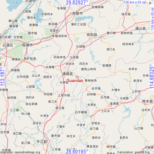
Guandao GPS coordinates[2]
29° 13' 2.82" North, 113° 54' 0.432" East
| Map corner | latitude | longitude |
|---|---|---|
| Upper-left | 29.82927°, | 113.197° |
| Center: | 29.21745°, | 113.90012° |
| Lower-right: | 28.60195°, | 114.60325° |
| Map W x H: | 136.5×136.5 km | = 84.8×84.8mi |
| max Lat: | 53.31946° ⇑63% North |
| Guandao: | 29.21745° |
| min Lat: | ⇓37% South 18.22056° |
| min Long | Guandao | max Long |
| 75.07348° | 113.90012° | 134.28917° |
| W 48%⇐ | ⇒52% E |
Elevation
Elevation of Guandao is 114 m = 374 ft, and this is 370.8 m = 1217 ft below average elevation for this country.
| Max E: |
5622 m = 18445 ft | 57.5% |
| Avg. | 484.8 m = 1591 ft | |
| Guandao | 114 m = 374 ft | |
Min E: |
-3 m = -10 ft | 42.5% |
See also: China elevation on elevation.city.
Geographical zone
Guandao is located in North temperate zone (between Tropic of Cancer and the Arctic Circle). Distance of this Northern Tropic circle is 642.8 km =399.4 mi to South.| Distance of | km | miles | from Guandao |
|---|---|---|---|
| North Pole | 6758.4 | 4199.5 | to North |
| Arctic Circle | 4152.5 | 2580.2 | to North |
| Tropic Cancer | 642.8 | 399.4 | to South |
| Equator | 3248.7 | 2018.6 | to South |


Nearby cities:
15 places around Guandao: (largest is in red/bold)
• Bailing
19.3 km =12 mi,  142°
142°
• Daping
23.9 km =14.9 mi,  301°
301°
• Gaojian
17.6 km =10.9 mi,  67°
67°
• Juanshui
9.6 km =6 mi,  352°
352°
• Lukou
23.8 km =14.8 mi,  129°
129°
• Magang
12.9 km =8 mi,  253°
253°
• Maishi
7.6 km =4.7 mi, 132°
• Quanfeng
19.2 km =11.9 mi,  120°
120°
• Shadui
9.8 km =6.1 mi,  358°
358°
• Shaping
17.9 km =11.1 mi, 350°
• Shinan
19.4 km =12.1 mi,  290°
290°
• Sizhuang
12.8 km =8 mi,  21°
21°
• Tanghu
8 km =5 mi,  93°
93°
• Wuli
11.5 km =7.1 mi,  271°
271°
• Xiaoling
17.4 km =10.8 mi,  328°
328°
Sources, notices
• [Note1] Compared only with cities in China existing in our database
• [Src1] Map data: © OpenStreetMap contributors (CC-BY-SA)
• [Src2] Other city data from geonames.org with taken over terms of usage.
• [Src3] Geographical zone / Annual Mean Temperature by Robert A. Rohde @ Wikipedia
