Gaojian geodata
Gaojian (Hubei) is a seat of a fourth-order administrative division; located in China in Asia/Shanghai (GMT+8) time zone. In our database, there are 1268 cities with bigger population. Compared to other cities in China, 62.3% of cities are located further ↑North; 50.9% of cities are located further →East and 54.3% of cities have lower elevation than Gaojian. Note1


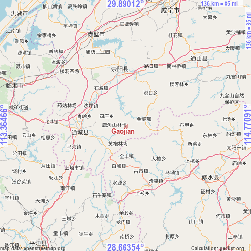
Gaojian GPS coordinates[2]
29° 16' 43.212" North, 114° 4' 4.008" East
| Map corner | latitude | longitude |
|---|---|---|
| Upper-left | 29.89012°, | 113.36466° |
| Center: | 29.27867°, | 114.06778° |
| Lower-right: | 28.66354°, | 114.77091° |
| Map W x H: | 136.4×136.4 km | = 84.8×84.8mi |
| max Lat: | 53.31946° ⇑62.3% North |
| Gaojian: | 29.27867° |
| min Lat: | ⇓37.7% South 18.22056° |
| min Long | Gaojian | max Long |
| 75.07348° | 114.06778° | 134.28917° |
| W 49.1%⇐ | ⇒50.9% E |
Elevation
Elevation of Gaojian is 200 m = 656 ft, and this is 284.8 m = 934 ft below average elevation for this country.
| Max E: |
5622 m = 18445 ft | 45.7% |
| Avg. | 484.8 m = 1591 ft | |
| Gaojian | 200 m = 656 ft | |
Min E: |
-3 m = -10 ft | 54.3% |
See also: China elevation on elevation.city.
Geographical zone
Gaojian is located in North temperate zone (between Tropic of Cancer and the Arctic Circle). Distance of this Northern Tropic circle is 649.6 km =403.6 mi to South.| Distance of | km | miles | from Gaojian |
|---|---|---|---|
| North Pole | 6751.6 | 4195.2 | to North |
| Arctic Circle | 4145.7 | 2576 | to North |
| Tropic Cancer | 649.6 | 403.6 | to South |
| Equator | 3255.5 | 2022.9 | to South |


Nearby cities:
15 places around Gaojian: (largest is in red/bold)
• Bailing
22.5 km =14 mi,  191°
191°
• Gangkou
22.2 km =13.8 mi,  35°
35°
• Guandao
17.6 km =10.9 mi,  247°
247°
• Jintang
10.7 km =6.6 mi,  68°
68°
• Juanshui
17.8 km =11.1 mi,  278°
278°
• Lukou
22.1 km =13.7 mi,  174°
174°
• Maishi
16.1 km =10 mi,  221°
221°
• Qingshan
18.4 km =11.4 mi,  345°
345°
• Quanfeng
16.7 km =10.4 mi,  179°
179°
• Shadui
16.7 km =10.4 mi, 280°
• Shaping
22 km =13.7 mi,  299°
299°
• Shicheng
24.9 km =15.5 mi,  326°
326°
• Sizhuang
12.6 km =7.8 mi,  293°
293°
• Tanghu
11 km =6.8 mi,  228°
228°
• Tongzhong
22.2 km =13.8 mi,  9°
9°
Sources, notices
• [Note1] Compared only with cities in China existing in our database
• [Src1] Map data: © OpenStreetMap contributors (CC-BY-SA)
• [Src2] Other city data from geonames.org with taken over terms of usage.
• [Src3] Geographical zone / Annual Mean Temperature by Robert A. Rohde @ Wikipedia
