Dafasi geodata
Dafasi (Hubei) is a seat of a fourth-order administrative division; located in China in Asia/Shanghai (GMT+8) time zone. In our database, there are 1268 cities with bigger population. Compared to other cities in China, 54.6% of cities are located further ↑North; 56.9% of cities are located further ←West and 75.7% of cities have higher elevation than Dafasi. Note1


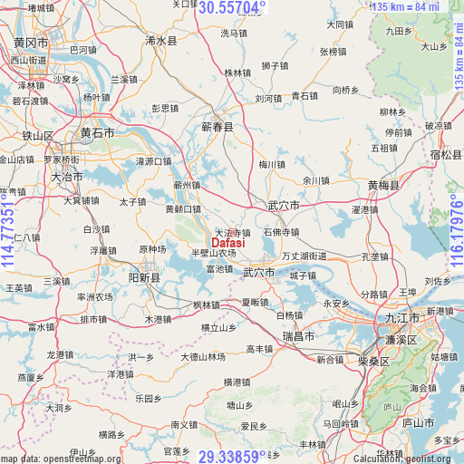
Dafasi GPS coordinates[2]
29° 56' 58.848" North, 115° 28' 35.868" East
| Map corner | latitude | longitude |
|---|---|---|
| Upper-left | 30.55704°, | 114.77351° |
| Center: | 29.94968°, | 115.47663° |
| Lower-right: | 29.33859°, | 116.17976° |
| Map W x H: | 135.5×135.5 km | = 84.2×84.2mi |
| max Lat: | 53.31946° ⇑54.6% North |
| Dafasi: | 29.94968° |
| min Lat: | ⇓45.4% South 18.22056° |
| min Long | Dafasi | max Long |
| 75.07348° | 115.47663° | 134.28917° |
| W 56.9%⇐ | ⇒43.1% E |
Elevation
Elevation of Dafasi is 35 m = 115 ft, and this is 449.8 m = 1476 ft below average elevation for this country.
| Max E: |
5622 m = 18445 ft | 75.7% |
| Avg. | 484.8 m = 1591 ft | |
| Dafasi | 35 m = 115 ft | |
Min E: |
-3 m = -10 ft | 24.3% |
See also: China elevation on elevation.city.
Geographical zone
Dafasi is located in North temperate zone (between Tropic of Cancer and the Arctic Circle). Distance of this Northern Tropic circle is 724.2 km =450 mi to South.| Distance of | km | miles | from Dafasi |
|---|---|---|---|
| North Pole | 6677 | 4148.9 | to North |
| Arctic Circle | 4071.1 | 2529.7 | to North |
| Tropic Cancer | 724.2 | 450 | to South |
| Equator | 3330.1 | 2069.2 | to South |


Nearby cities:
15 places around Dafasi: (largest is in red/bold)
• Dajin
14.1 km =8.8 mi,  67°
67°
• Fenglin
22.3 km =13.9 mi,  200°
200°
• Fuchi
11.2 km =7 mi, 199°
• Huangjin
19.2 km =11.9 mi,  178°
178°
• Huangsangkou
16 km =9.9 mi,  296°
296°
• Matou
16.3 km =10.1 mi,  143°
143°
• Meichuan
23.1 km =14.4 mi,  29°
29°
• Qizhou
19 km =11.8 mi,  313°
313°
• Shifosi
14.2 km =8.8 mi,  88°
88°
• Siwang
11.3 km =7 mi,  39°
39°
• Tianzhen
9.2 km =5.7 mi, 182°
• Wuxue
13.2 km =8.2 mi,  146°
146°
• Wuxue Shi
7.1 km =4.4 mi,  237°
237°
• Xiafan
21.2 km =13.2 mi,  162°
162°
• Xingguo
17.1 km =10.6 mi,  259°
259°
Sources, notices
• [Note1] Compared only with cities in China existing in our database
• [Src1] Map data: © OpenStreetMap contributors (CC-BY-SA)
• [Src2] Other city data from geonames.org with taken over terms of usage.
• [Src3] Geographical zone / Annual Mean Temperature by Robert A. Rohde @ Wikipedia
