Shifosi geodata
Shifosi (Hubei) is a seat of a fourth-order administrative division; located in China in Asia/Shanghai (GMT+8) time zone. In our database, there are 1268 cities with bigger population. Compared to other cities in China, 54.6% of cities are located further ↑North; 57.7% of cities are located further ←West and 73.7% of cities have higher elevation than Shifosi. Note1


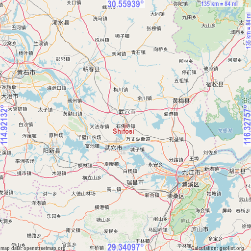
Shifosi GPS coordinates[2]
29° 57' 7.38" North, 115° 37' 27.984" East
| Map corner | latitude | longitude |
|---|---|---|
| Upper-left | 30.55939°, | 114.92132° |
| Center: | 29.95205°, | 115.62444° |
| Lower-right: | 29.34097°, | 116.32757° |
| Map W x H: | 135.5×135.5 km | = 84.2×84.2mi |
| max Lat: | 53.31946° ⇑54.6% North |
| Shifosi: | 29.95205° |
| min Lat: | ⇓45.4% South 18.22056° |
| min Long | Shifosi | max Long |
| 75.07348° | 115.62444° | 134.28917° |
| W 57.7%⇐ | ⇒42.3% E |
Elevation
Elevation of Shifosi is 40 m = 131 ft, and this is 444.8 m = 1459 ft below average elevation for this country.
| Max E: |
5622 m = 18445 ft | 73.7% |
| Avg. | 484.8 m = 1591 ft | |
| Shifosi | 40 m = 131 ft | |
Min E: |
-3 m = -10 ft | 26.3% |
See also: China elevation on elevation.city.
Geographical zone
Shifosi is located in North temperate zone (between Tropic of Cancer and the Arctic Circle). Distance of this Northern Tropic circle is 724.4 km =450.1 mi to South.| Distance of | km | miles | from Shifosi |
|---|---|---|---|
| North Pole | 6676.7 | 4148.7 | to North |
| Arctic Circle | 4070.8 | 2529.5 | to North |
| Tropic Cancer | 724.4 | 450.1 | to South |
| Equator | 3330.4 | 2069.4 | to South |


Nearby cities:
15 places around Shifosi: (largest is in red/bold)
• Caishan
17.4 km =10.8 mi,  115°
115°
• Chengzi
14.1 km =8.8 mi,  154°
154°
• Dafasi
14.2 km =8.8 mi,  268°
268°
• Dajin
5.2 km =3.2 mi,  346°
346°
• Huaqiao
11.2 km =7 mi,  52°
52°
• Longping
11.6 km =7.2 mi,  142°
142°
• Matou
14.2 km =8.8 mi,  198°
198°
• Meichuan
19.9 km =12.4 mi, 352°
• Siwang
11 km =6.8 mi,  320°
320°
• Tianzhen
17.5 km =10.9 mi,  237°
237°
• Wujiao
20.4 km =12.7 mi,  180°
180°
• Wuxue
13.2 km =8.2 mi,  211°
211°
• Wuxue Shi
20.7 km =12.9 mi,  258°
258°
• Yuchuan
18.1 km =11.2 mi,  33°
33°
• Zhanghekou
12.9 km =8 mi,  68°
68°
Sources, notices
• [Note1] Compared only with cities in China existing in our database
• [Src1] Map data: © OpenStreetMap contributors (CC-BY-SA)
• [Src2] Other city data from geonames.org with taken over terms of usage.
• [Src3] Geographical zone / Annual Mean Temperature by Robert A. Rohde @ Wikipedia
