Xiafan geodata
Xiafan (Jiangxi) is a seat of a fourth-order administrative division; located in China in Asia/Shanghai (GMT+8) time zone. In our database, there are 1268 cities with bigger population. Compared to other cities in China, 56.7% of cities are located further ↑North; 57.2% of cities are located further ←West and 82.9% of cities have higher elevation than Xiafan. Note1


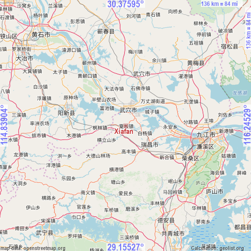
Xiafan GPS coordinates[2]
29° 46' 2.892" North, 115° 32' 31.776" East
| Map corner | latitude | longitude |
|---|---|---|
| Upper-left | 30.37595°, | 114.83904° |
| Center: | 29.76747°, | 115.54216° |
| Lower-right: | 29.15527°, | 116.24529° |
| Map W x H: | 135.7×135.7 km | = 84.3×84.3mi |
| max Lat: | 53.31946° ⇑56.7% North |
| Xiafan: | 29.76747° |
| min Lat: | ⇓43.3% South 18.22056° |
| min Long | Xiafan | max Long |
| 75.07348° | 115.54216° | 134.28917° |
| W 57.2%⇐ | ⇒42.8% E |
Elevation
Elevation of Xiafan is 20 m = 66 ft, and this is 464.8 m = 1525 ft below average elevation for this country.
| Max E: |
5622 m = 18445 ft | 82.9% |
| Avg. | 484.8 m = 1591 ft | |
| Xiafan | 20 m = 66 ft | |
Min E: |
-3 m = -10 ft | 17.1% |
See also: China elevation on elevation.city.
Geographical zone
Xiafan is located in North temperate zone (between Tropic of Cancer and the Arctic Circle). Distance of this Northern Tropic circle is 703.9 km =437.4 mi to South.| Distance of | km | miles | from Xiafan |
|---|---|---|---|
| North Pole | 6697.2 | 4161.4 | to North |
| Arctic Circle | 4091.3 | 2542.2 | to North |
| Tropic Cancer | 703.9 | 437.4 | to South |
| Equator | 3309.8 | 2056.6 | to South |


Nearby cities:
15 places around Xiafan: (largest is in red/bold)
• Baiyang
11 km =6.8 mi,  110°
110°
• Chengzi
16.1 km =10 mi,  61°
61°
• Fenglin
14.1 km =8.8 mi,  267°
267°
• Fuchi
14 km =8.7 mi,  314°
314°
• Gaofeng
13.9 km =8.6 mi,  174°
174°
• Henglishan
12.8 km =8 mi,  234°
234°
• Huangjin
5.9 km =3.7 mi,  280°
280°
• Leshan
20.5 km =12.7 mi,  198°
198°
• Longping
18.8 km =11.7 mi,  52°
52°
• Matou
7.9 km =4.9 mi,  25°
25°
• Nanyang
4.4 km =2.7 mi,  215°
215°
• Neihu
14.3 km =8.9 mi,  247°
247°
• Tianzhen
13 km =8.1 mi,  328°
328°
• Wujiao
7.8 km =4.8 mi,  88°
88°
• Wuxue
9.3 km =5.8 mi,  6°
6°
Sources, notices
• [Note1] Compared only with cities in China existing in our database
• [Src1] Map data: © OpenStreetMap contributors (CC-BY-SA)
• [Src2] Other city data from geonames.org with taken over terms of usage.
• [Src3] Geographical zone / Annual Mean Temperature by Robert A. Rohde @ Wikipedia
