Fuchi geodata
Fuchi (Hubei) is a seat of a fourth-order administrative division; located in China in Asia/Shanghai (GMT+8) time zone. In our database, there are 1268 cities with bigger population. Compared to other cities in China, 55.7% of cities are located further ↑North; 56.7% of cities are located further ←West and 79.3% of cities have higher elevation than Fuchi. Note1


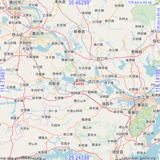
Fuchi GPS coordinates[2]
29° 51' 18.18" North, 115° 26' 16.62" East
| Map corner | latitude | longitude |
|---|---|---|
| Upper-left | 30.46299°, | 114.73483° |
| Center: | 29.85505°, | 115.43795° |
| Lower-right: | 29.24338°, | 116.14108° |
| Map W x H: | 135.6×135.6 km | = 84.3×84.3mi |
| max Lat: | 53.31946° ⇑55.7% North |
| Fuchi: | 29.85505° |
| min Lat: | ⇓44.3% South 18.22056° |
| min Long | Fuchi | max Long |
| 75.07348° | 115.43795° | 134.28917° |
| W 56.7%⇐ | ⇒43.3% E |
Elevation
Elevation of Fuchi is 28 m = 92 ft, and this is 456.8 m = 1499 ft below average elevation for this country.
| Max E: |
5622 m = 18445 ft | 79.3% |
| Avg. | 484.8 m = 1591 ft | |
| Fuchi | 28 m = 92 ft | |
Min E: |
-3 m = -10 ft | 20.7% |
See also: China elevation on elevation.city.
Geographical zone
Fuchi is located in North temperate zone (between Tropic of Cancer and the Arctic Circle). Distance of this Northern Tropic circle is 713.7 km =443.5 mi to South.| Distance of | km | miles | from Fuchi |
|---|---|---|---|
| North Pole | 6687.5 | 4155.4 | to North |
| Arctic Circle | 4081.6 | 2536.2 | to North |
| Tropic Cancer | 713.7 | 443.5 | to South |
| Equator | 3319.6 | 2062.7 | to South |


Nearby cities:
15 places around Fuchi: (largest is in red/bold)
• Dafasi
11.2 km =7 mi,  19°
19°
• Fenglin
11.2 km =7 mi,  201°
201°
• Henglishan
17.2 km =10.7 mi,  181°
181°
• Huangjin
9.7 km =6 mi,  154°
154°
• Huangsangkou
20.6 km =12.8 mi,  329°
329°
• Matou
13.7 km =8.5 mi,  101°
101°
• Nanyang
15.3 km =9.5 mi, 150°
• Neihu
15.5 km =9.6 mi,  191°
191°
• Shifosi
21 km =13 mi,  59°
59°
• Tianzhen
3.5 km =2.2 mi,  67°
67°
• Wujiao
20.2 km =12.6 mi,  118°
118°
• Wuxue
11.1 km =6.9 mi,  92°
92°
• Wuxue Shi
7.1 km =4.4 mi,  341°
341°
• Xiafan
14 km =8.7 mi,  134°
134°
• Xingguo
15.1 km =9.4 mi,  299°
299°
Sources, notices
• [Note1] Compared only with cities in China existing in our database
• [Src1] Map data: © OpenStreetMap contributors (CC-BY-SA)
• [Src2] Other city data from geonames.org with taken over terms of usage.
• [Src3] Geographical zone / Annual Mean Temperature by Robert A. Rohde @ Wikipedia
