Matou geodata
Matou (Jiangxi) is a seat of a fourth-order administrative division; located in China in Asia/Shanghai (GMT+8) time zone. In our database, there are 1268 cities with bigger population. Compared to other cities in China, 56% of cities are located further ↑North; 57.4% of cities are located further ←West and 80.2% of cities have higher elevation than Matou. Note1


Matou GPS coordinates[2]
29° 49' 53.256" North, 115° 34' 38.604" East
| Map corner | latitude | longitude |
|---|---|---|
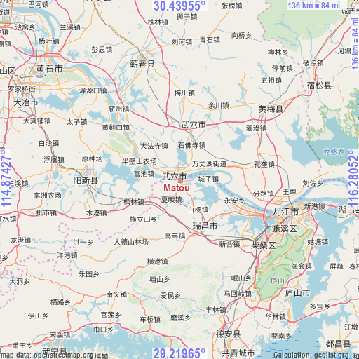
| Upper-left | 30.43955°, | 114.87427° |
| Center: | 29.83146°, | 115.57739° |
| Lower-right: | 29.21965°, | 116.28052° |
| Map W x H: | 135.6×135.6 km | = 84.3×84.3mi |
| max Lat: | 53.31946° ⇑56% North |
| Matou: | 29.83146° |
| min Lat: | ⇓44% South 18.22056° |
| min Long | Matou | max Long |
| 75.07348° | 115.57739° | 134.28917° |
| W 57.4%⇐ | ⇒42.6% E |
Elevation
Elevation of Matou is 26 m = 85 ft, and this is 458.8 m = 1505 ft below average elevation for this country.
| Max E: |
5622 m = 18445 ft | 80.2% |
| Avg. | 484.8 m = 1591 ft | |
| Matou | 26 m = 85 ft | |
Min E: |
-3 m = -10 ft | 19.8% |
See also: China elevation on elevation.city.
Geographical zone
Matou is located in North temperate zone (between Tropic of Cancer and the Arctic Circle). Distance of this Northern Tropic circle is 711 km =441.8 mi to South.| Distance of | km | miles | from Matou |
|---|---|---|---|
| North Pole | 6690.1 | 4157 | to North |
| Arctic Circle | 4084.2 | 2537.8 | to North |
| Tropic Cancer | 711 | 441.8 | to South |
| Equator | 3316.9 | 2061 | to South |


Nearby cities:
15 places around Matou: (largest is in red/bold)
• Baiyang
12.9 km =8 mi,  147°
147°
• Chengzi
10.7 km =6.6 mi,  86°
86°
• Dafasi
16.3 km =10.1 mi,  323°
323°
• Dajin
18.8 km =11.7 mi,  10°
10°
• Fenglin
19.1 km =11.9 mi,  245°
245°
• Fuchi
13.7 km =8.5 mi,  281°
281°
• Huangjin
11 km =6.8 mi,  236°
236°
• Longping
12.3 km =7.6 mi,  69°
69°
• Nanyang
12.3 km =7.6 mi,  209°
209°
• Shifosi
14.2 km =8.8 mi,  18°
18°
• Tianzhen
10.9 km =6.8 mi,  291°
291°
• Wujiao
8.2 km =5.1 mi, 148°
• Wuxue
3.2 km =2 mi,  311°
311°
• Wuxue Shi
18.3 km =11.4 mi,  300°
300°
• Xiafan
7.9 km =4.9 mi, 205°
Sources, notices
• [Note1] Compared only with cities in China existing in our database
• [Src1] Map data: © OpenStreetMap contributors (CC-BY-SA)
• [Src2] Other city data from geonames.org with taken over terms of usage.
• [Src3] Geographical zone / Annual Mean Temperature by Robert A. Rohde @ Wikipedia
