Wuxue geodata
Wuxue (Hubei) is a seat of a third-order administrative division; located in China in Asia/Shanghai (GMT+8) time zone. With population of 220,661 people, there are 217 cities with bigger population in this country. Compared to other cities in China, 55.7% of cities are located further ↑North; 57.3% of cities are located further ←West and 81.6% of cities have higher elevation than Wuxue. Note1


Wuxue GPS coordinates[2]
29° 51' 2.088" North, 115° 33' 9" East
| Map corner | latitude | longitude |
|---|---|---|
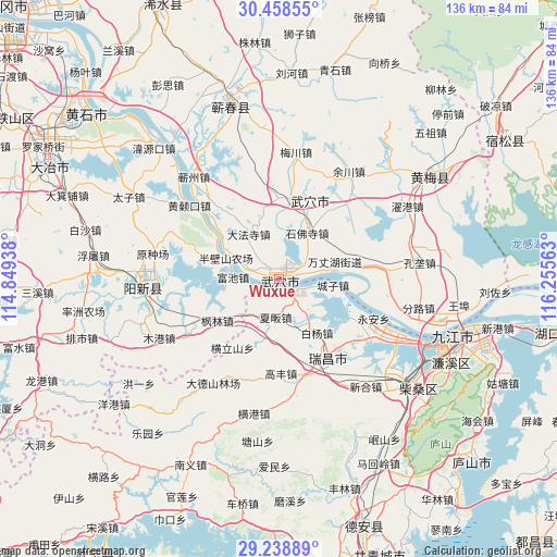
| Upper-left | 30.45855°, | 114.84938° |
| Center: | 29.85058°, | 115.5525° |
| Lower-right: | 29.23889°, | 116.25563° |
| Map W x H: | 135.6×135.6 km | = 84.3×84.3mi |
| max Lat: | 53.31946° ⇑55.7% North |
| Wuxue: | 29.85058° |
| min Lat: | ⇓44.3% South 18.22056° |
| min Long | Wuxue | max Long |
| 75.07348° | 115.5525° | 134.28917° |
| W 57.3%⇐ | ⇒42.7% E |
Elevation
Elevation of Wuxue is 23 m = 75 ft, and this is 461.8 m = 1515 ft below average elevation for this country.
| Max E: |
5622 m = 18445 ft | 81.6% |
| Avg. | 484.8 m = 1591 ft | |
| Wuxue | 23 m = 75 ft | |
Min E: |
-3 m = -10 ft | 18.4% |
See also: Wuxue elevation on elevation.city.
Geographical zone
Wuxue is located in North temperate zone (between Tropic of Cancer and the Arctic Circle). Distance of this Northern Tropic circle is 713.2 km =443.2 mi to South.| Distance of | km | miles | from Wuxue |
|---|---|---|---|
| North Pole | 6688 | 4155.7 | to North |
| Arctic Circle | 4082.1 | 2536.5 | to North |
| Tropic Cancer | 713.2 | 443.2 | to South |
| Equator | 3319.1 | 2062.4 | to South |


Nearby cities:
15 places around Wuxue: (largest is in red/bold)
• Baiyang
16 km =9.9 mi,  144°
144°
• Chengzi
13.2 km =8.2 mi,  96°
96°
• Dafasi
13.2 km =8.2 mi,  326°
326°
• Dajin
17.4 km =10.8 mi,  19°
19°
• Fenglin
18 km =11.2 mi,  236°
236°
• Fuchi
11.1 km =6.9 mi,  272°
272°
• Huangjin
10.7 km =6.6 mi,  219°
219°
• Longping
14.1 km =8.8 mi,  81°
81°
• Matou
3.2 km =2 mi,  131°
131°
• Nanyang
13.4 km =8.3 mi,  195°
195°
• Shifosi
13.2 km =8.2 mi,  31°
31°
• Tianzhen
8 km =5 mi,  283°
283°
• Wujiao
11.3 km =7 mi, 143°
• Wuxue Shi
15.1 km =9.4 mi,  298°
298°
• Xiafan
9.3 km =5.8 mi,  186°
186°
Sources, notices
• [Note1] Compared only with cities in China existing in our database
• [Src1] Map data: © OpenStreetMap contributors (CC-BY-SA)
• [Src2] Other city data from geonames.org with taken over terms of usage.
• [Src3] Geographical zone / Annual Mean Temperature by Robert A. Rohde @ Wikipedia
