Hongqi geodata
Hongqi (Liaoning) is a seat of a fourth-order administrative division; located in China in Asia/Shanghai (GMT+8) time zone. In our database, there are 1268 cities with bigger population. Compared to other cities in China, 86.9% of cities are located further ↓South; 93.6% of cities are located further ←West and 64.9% of cities have higher elevation than Hongqi. Note1


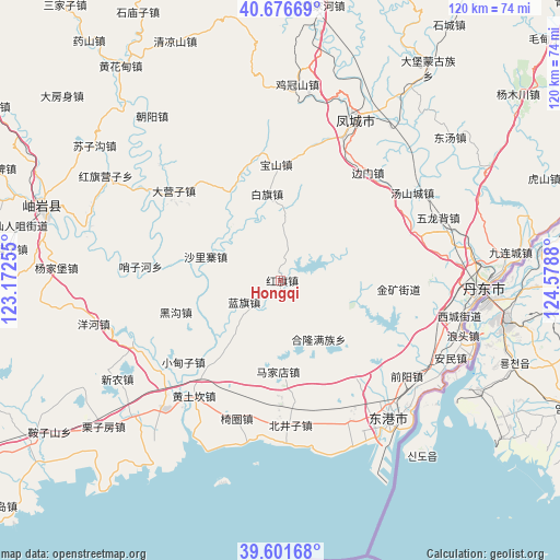
Hongqi GPS coordinates[2]
40° 8' 28.716" North, 123° 52' 32.412" East
| Map corner | latitude | longitude |
|---|---|---|
| Upper-left | 40.67669°, | 123.17255° |
| Center: | 40.14131°, | 123.87567° |
| Lower-right: | 39.60168°, | 124.5788° |
| Map W x H: | 119.5×119.5 km | = 74.3×74.3mi |
| max Lat: | 53.31946° ⇑13.1% North |
| Hongqi: | 40.14131° |
| min Lat: | ⇓86.9% South 18.22056° |
| min Long | Hongqi | max Long |
| 75.07348° | 123.87567° | 134.28917° |
| W 93.6%⇐ | ⇒6.4% E |
Elevation
Elevation of Hongqi is 73 m = 240 ft, and this is 411.8 m = 1351 ft below average elevation for this country.
| Max E: |
5622 m = 18445 ft | 64.9% |
| Avg. | 484.8 m = 1591 ft | |
| Hongqi | 73 m = 240 ft | |
Min E: |
-3 m = -10 ft | 35.1% |
See also: China elevation on elevation.city.
Geographical zone
Hongqi is located in North temperate zone (between Tropic of Cancer and the Arctic Circle). Distance of this Northern Tropic circle is 1857.4 km =1154.1 mi to South.| Distance of | km | miles | from Hongqi |
|---|---|---|---|
| North Pole | 5543.8 | 3444.8 | to North |
| Arctic Circle | 2937.9 | 1825.5 | to North |
| Tropic Cancer | 1857.4 | 1154.1 | to South |
| Equator | 4463.3 | 2773.4 | to South |


Nearby cities:
15 places around Hongqi: (largest is in red/bold)
• Baiqi
19 km =11.8 mi,  351°
351°
• Baoshan
24.8 km =15.4 mi,  357°
357°
• Chaoyang
44.7 km =27.8 mi,  321°
321°
• Dandong
44.1 km =27.4 mi,  91°
91°
• Dayingzi
29.8 km =18.5 mi,  310°
310°
• Fengcheng
38.5 km =23.9 mi,  25°
25°
• Heigou
23.8 km =14.8 mi,  253°
253°
• Hongqi Yingzi
43 km =26.7 mi,  299°
299°
• Jiguanshan
42.3 km =26.3 mi,  4°
4°
• Langtoucun
40.7 km =25.3 mi,  105°
105°
• Lanqi
8.9 km =5.5 mi,  240°
240°
• Linggou
38.1 km =23.7 mi,  275°
275°
• Shalizhai
16.5 km =10.3 mi,  285°
285°
• Xinxing
37.1 km =23.1 mi,  145°
145°
• Yanghe
40.8 km =25.4 mi,  256°
256°
Sources, notices
• [Note1] Compared only with cities in China existing in our database
• [Src1] Map data: © OpenStreetMap contributors (CC-BY-SA)
• [Src2] Other city data from geonames.org with taken over terms of usage.
• [Src3] Geographical zone / Annual Mean Temperature by Robert A. Rohde @ Wikipedia
