Baiqi geodata
Baiqi (Liaoning) is a seat of a fourth-order administrative division; located in China in Asia/Shanghai (GMT+8) time zone. In our database, there are 1268 cities with bigger population. Compared to other cities in China, 87.5% of cities are located further ↓South; 93.6% of cities are located further ←West and 66.4% of cities have higher elevation than Baiqi. Note1


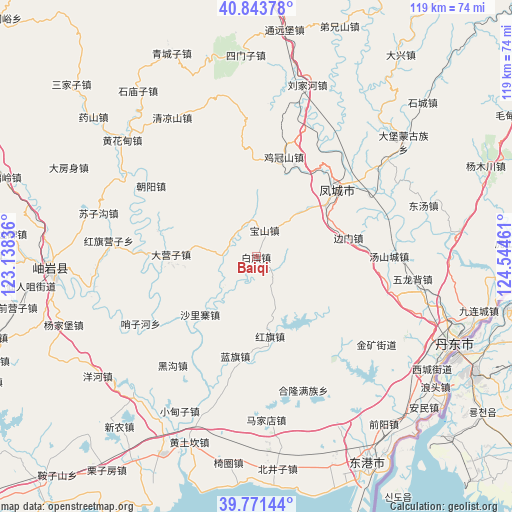
Baiqi GPS coordinates[2]
40° 18' 35.064" North, 123° 50' 29.328" East
| Map corner | latitude | longitude |
|---|---|---|
| Upper-left | 40.84378°, | 123.13836° |
| Center: | 40.30974°, | 123.84148° |
| Lower-right: | 39.77144°, | 124.54461° |
| Map W x H: | 119.2×119.2 km | = 74.1×74.1mi |
| max Lat: | 53.31946° ⇑12.5% North |
| Baiqi: | 40.30974° |
| min Lat: | ⇓87.5% South 18.22056° |
| min Long | Baiqi | max Long |
| 75.07348° | 123.84148° | 134.28917° |
| W 93.6%⇐ | ⇒6.4% E |
Elevation
Elevation of Baiqi is 67 m = 220 ft, and this is 417.8 m = 1371 ft below average elevation for this country.
| Max E: |
5622 m = 18445 ft | 66.4% |
| Avg. | 484.8 m = 1591 ft | |
| Baiqi | 67 m = 220 ft | |
Min E: |
-3 m = -10 ft | 33.6% |
See also: China elevation on elevation.city.
Geographical zone
Baiqi is located in North temperate zone (between Tropic of Cancer and the Arctic Circle). Distance of this Northern Tropic circle is 1876.1 km =1165.8 mi to South.| Distance of | km | miles | from Baiqi |
|---|---|---|---|
| North Pole | 5525 | 3433.1 | to North |
| Arctic Circle | 2919.2 | 1813.9 | to North |
| Tropic Cancer | 1876.1 | 1165.8 | to South |
| Equator | 4482 | 2785 | to South |


Nearby cities:
15 places around Baiqi: (largest is in red/bold)
• Baoshan
6.3 km =3.9 mi,  15°
15°
• Chaoyang
29.6 km =18.4 mi,  303°
303°
• Dayingzi
19.8 km =12.3 mi,  271°
271°
• Fengcheng
25.2 km =15.7 mi,  50°
50°
• Hanghuadian
41.8 km =26 mi,  311°
311°
• Heigou
32.2 km =20 mi,  218°
218°
• Hongqi
19 km =11.8 mi,  171°
171°
• Hongqi Yingzi
34.4 km =21.4 mi, 274°
• Jiguanshan
24.2 km =15 mi,  14°
14°
• Lanqi
23.6 km =14.7 mi,  191°
191°
• Linggou
38.1 km =23.7 mi,  246°
246°
• Liujiahe
41.7 km =25.9 mi, 16°
• Shalizhai
19.3 km =12 mi, 222°
• Suzigou
38 km =23.6 mi,  285°
285°
• Tanggou
37.8 km =23.5 mi,  328°
328°
Sources, notices
• [Note1] Compared only with cities in China existing in our database
• [Src1] Map data: © OpenStreetMap contributors (CC-BY-SA)
• [Src2] Other city data from geonames.org with taken over terms of usage.
• [Src3] Geographical zone / Annual Mean Temperature by Robert A. Rohde @ Wikipedia
