Cheren geodata
Cheren (Tibet) is a seat of a fourth-order administrative division; located in China in Asia/Shanghai (GMT+8) time zone. In our database, there are 1268 cities with bigger population. Compared to other cities in China, 66.7% of cities are located further ↑North; 97.3% of cities are located further →East and 98.8% of cities have lower elevation than Cheren. Note1


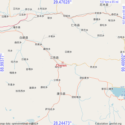
Cheren GPS coordinates[2]
28° 51' 44.388" North, 89° 41' 48.804" East
| Map corner | latitude | longitude |
|---|---|---|
| Upper-left | 29.47628°, | 88.99377° |
| Center: | 28.86233°, | 89.69689° |
| Lower-right: | 28.24473°, | 90.40002° |
| Map W x H: | 136.9×136.9 km | = 85.1×85.1mi |
| max Lat: | 53.31946° ⇑66.7% North |
| Cheren: | 28.86233° |
| min Lat: | ⇓33.3% South 18.22056° |
| min Long | Cheren | max Long |
| 75.07348° | 89.69689° | 134.28917° |
| W 2.7%⇐ | ⇒97.3% E |
Elevation
Elevation of Cheren is 4108 m = 13478 ft, and this is 3623.2 m = 11887 ft above average elevation for this country.
| Max E: |
5622 m = 18445 ft | 1.2% |
| Cheren | 4108 m 13478 ft | |
| Avg. | 484.8 m = 1591 ft | |
Min E: |
-3 m = -10 ft | 98.8% |
See also: China elevation on elevation.city.
Geographical zone
Cheren is located in North temperate zone (between Tropic of Cancer and the Arctic Circle). Distance of this Northern Tropic circle is 603.3 km =374.9 mi to South.| Distance of | km | miles | from Cheren |
|---|---|---|---|
| North Pole | 6797.9 | 4224 | to North |
| Arctic Circle | 4192 | 2604.8 | to North |
| Tropic Cancer | 603.3 | 374.9 | to South |
| Equator | 3209.2 | 1994.1 | to South |


Nearby cities:
15 places around Cheren: (largest is in red/bold)
• Jangra
12.9 km =8 mi,  290°
290°
• Jiangzi
11.5 km =7.1 mi,  304°
304°
• Kamru
33.6 km =20.9 mi,  217°
217°
• Kangmar
33.7 km =20.9 mi,  182°
182°
• Kangzhuo
19.8 km =12.3 mi,  278°
278°
• Kardoi
31.4 km =19.5 mi,  337°
337°
• Lungmar
23.7 km =14.7 mi,  91°
91°
• Nanni
6.2 km =3.9 mi,  226°
226°
• Narong
32.2 km =20 mi,  346°
346°
• Niandui
4.6 km =2.9 mi,  309°
309°
• Nierumai
28.8 km =17.9 mi,  124°
124°
• Rasog
33.3 km =20.7 mi, 308°
• Zangka
23 km =14.3 mi, 311°
• Zhongzi
29.1 km =18.1 mi, 307°
• Zijin
17.2 km =10.7 mi, 292°
Sources, notices
• [Note1] Compared only with cities in China existing in our database
• [Src1] Map data: © OpenStreetMap contributors (CC-BY-SA)
• [Src2] Other city data from geonames.org with taken over terms of usage.
• [Src3] Geographical zone / Annual Mean Temperature by Robert A. Rohde @ Wikipedia
