Chaoyangdong geodata
Chaoyangdong (Chongqing) is a seat of a fourth-order administrative division; located in China in Asia/Shanghai (GMT+8) time zone. In our database, there are 1268 cities with bigger population. Compared to other cities in China, 57.8% of cities are located further ↓South; 76% of cities are located further →East and 81.5% of cities have lower elevation than Chaoyangdong. Note1


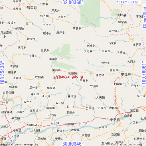
Chaoyangdong GPS coordinates[2]
31° 24' 19.764" North, 109° 3' 26.928" East
| Map corner | latitude | longitude |
|---|---|---|
| Upper-left | 32.00368°, | 108.35436° |
| Center: | 31.40549°, | 109.05748° |
| Lower-right: | 30.80346°, | 109.76061° |
| Map W x H: | 133.5×133.5 km | = 83×83mi |
| max Lat: | 53.31946° ⇑42.2% North |
| Chaoyangdong: | 31.40549° |
| min Lat: | ⇓57.8% South 18.22056° |
| min Long | Chaoyangdong | max Long |
| 75.07348° | 109.05748° | 134.28917° |
| W 24%⇐ | ⇒76% E |
Elevation
Elevation of Chaoyangdong is 765 m = 2510 ft, and this is 280.2 m = 919 ft above average elevation for this country.
| Max E: |
5622 m = 18445 ft | 18.5% |
| Chaoyangdong | 765 m 2510 ft | |
| Avg. | 484.8 m = 1591 ft | |
Min E: |
-3 m = -10 ft | 81.5% |
See also: China elevation on elevation.city.
Geographical zone
Chaoyangdong is located in North temperate zone (between Tropic of Cancer and the Arctic Circle). Distance of this Northern Tropic circle is 886 km =550.5 mi to South.| Distance of | km | miles | from Chaoyangdong |
|---|---|---|---|
| North Pole | 6515.1 | 4048.3 | to North |
| Arctic Circle | 3909.2 | 2429.1 | to North |
| Tropic Cancer | 886 | 550.5 | to South |
| Equator | 3492 | 2169.8 | to South |


Nearby cities:
15 places around Chaoyangdong: (largest is in red/bold)
• Jianshan
15.7 km =9.8 mi,  281°
281°
• Nongba
30.3 km =18.8 mi,  264°
264°
• Ping’an
11.2 km =7 mi,  123°
123°
• Sangping
20.9 km =13 mi,  183°
183°
• Shashi
18.2 km =11.3 mi,  244°
244°
• Taiyang
27.3 km =17 mi,  189°
189°
• Tangfang
23.9 km =14.9 mi,  93°
93°
• Tianba
18.5 km =11.5 mi,  268°
268°
• Tuba
14.7 km =9.1 mi, 255°
• Tucheng
30 km =18.6 mi,  32°
32°
• Wenfeng
16.8 km =10.4 mi, 90°
• Xinzheng
19.4 km =12.1 mi,  164°
164°
• Yuquan
23.9 km =14.9 mi, 235°
• Zhonggang
22.2 km =13.8 mi,  306°
306°
• Zhuyuan
22.2 km =13.8 mi, 121°
Sources, notices
• [Note1] Compared only with cities in China existing in our database
• [Src1] Map data: © OpenStreetMap contributors (CC-BY-SA)
• [Src2] Other city data from geonames.org with taken over terms of usage.
• [Src3] Geographical zone / Annual Mean Temperature by Robert A. Rohde @ Wikipedia
