Sangping geodata
Sangping (Chongqing) is a seat of a fourth-order administrative division; located in China in Asia/Shanghai (GMT+8) time zone. In our database, there are 1268 cities with bigger population. Compared to other cities in China, 56.4% of cities are located further ↓South; 76.1% of cities are located further →East and 81.6% of cities have lower elevation than Sangping. Note1


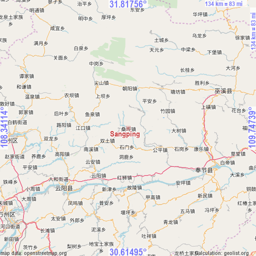
Sangping GPS coordinates[2]
31° 13' 5.412" North, 109° 2' 39.336" East
| Map corner | latitude | longitude |
|---|---|---|
| Upper-left | 31.81756°, | 108.34114° |
| Center: | 31.21817°, | 109.04426° |
| Lower-right: | 30.61495°, | 109.74739° |
| Map W x H: | 133.7×133.7 km | = 83.1×83.1mi |
| max Lat: | 53.31946° ⇑43.6% North |
| Sangping: | 31.21817° |
| min Lat: | ⇓56.4% South 18.22056° |
| min Long | Sangping | max Long |
| 75.07348° | 109.04426° | 134.28917° |
| W 23.9%⇐ | ⇒76.1% E |
Elevation
Elevation of Sangping is 771 m = 2530 ft, and this is 286.2 m = 939 ft above average elevation for this country.
| Max E: |
5622 m = 18445 ft | 18.4% |
| Sangping | 771 m 2530 ft | |
| Avg. | 484.8 m = 1591 ft | |
Min E: |
-3 m = -10 ft | 81.6% |
See also: China elevation on elevation.city.
Geographical zone
Sangping is located in North temperate zone (between Tropic of Cancer and the Arctic Circle). Distance of this Northern Tropic circle is 865.2 km =537.6 mi to South.| Distance of | km | miles | from Sangping |
|---|---|---|---|
| North Pole | 6535.9 | 4061.2 | to North |
| Arctic Circle | 3930 | 2442 | to North |
| Tropic Cancer | 865.2 | 537.6 | to South |
| Equator | 3471.1 | 2156.8 | to South |


Nearby cities:
15 places around Sangping: (largest is in red/bold)
• Chaoyangdong
20.9 km =13 mi,  3°
3°
• Donglu
14.4 km =8.9 mi,  181°
181°
• Gongping
17.7 km =11 mi,  124°
124°
• Hongshi
25.7 km =16 mi, 184°
• Hongtu
11.6 km =7.2 mi,  154°
154°
• Jiangkou
23.8 km =14.8 mi,  271°
271°
• Nanxi
22.9 km =14.2 mi,  239°
239°
• Ping’an
18.1 km =11.2 mi,  35°
35°
• Shashi
20.1 km =12.5 mi,  310°
310°
• Shimen
9.6 km =6 mi, 184°
• Taiyang
6.9 km =4.3 mi,  208°
208°
• Tuba
21.5 km =13.4 mi,  322°
322°
• Xinzheng
6.7 km =4.2 mi,  71°
71°
• Yuquan
20 km =12.4 mi,  291°
291°
• Zhuyuan
22.4 km =13.9 mi, 65°
Sources, notices
• [Note1] Compared only with cities in China existing in our database
• [Src1] Map data: © OpenStreetMap contributors (CC-BY-SA)
• [Src2] Other city data from geonames.org with taken over terms of usage.
• [Src3] Geographical zone / Annual Mean Temperature by Robert A. Rohde @ Wikipedia
