Tianba geodata
Tianba (Chongqing) is a seat of a fourth-order administrative division; located in China in Asia/Shanghai (GMT+8) time zone. In our database, there are 1268 cities with bigger population. Compared to other cities in China, 57.8% of cities are located further ↓South; 77% of cities are located further →East and 64.4% of cities have lower elevation than Tianba. Note1


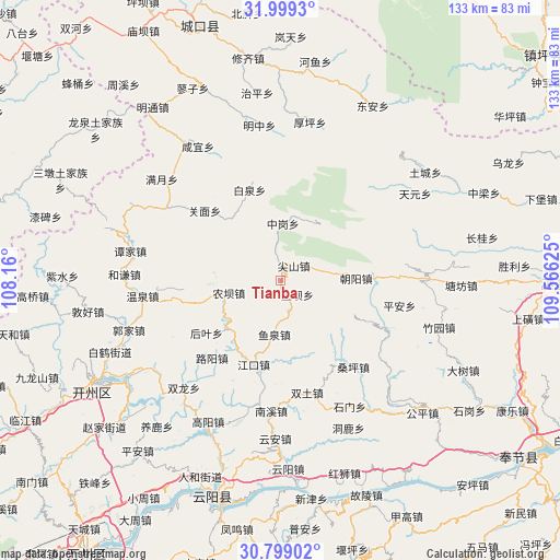
Tianba GPS coordinates[2]
31° 24' 3.888" North, 108° 51' 47.232" East
| Map corner | latitude | longitude |
|---|---|---|
| Upper-left | 31.9993°, | 108.16° |
| Center: | 31.40108°, | 108.86312° |
| Lower-right: | 30.79902°, | 109.56625° |
| Map W x H: | 133.5×133.5 km | = 83×83mi |
| max Lat: | 53.31946° ⇑42.2% North |
| Tianba: | 31.40108° |
| min Lat: | ⇓57.8% South 18.22056° |
| min Long | Tianba | max Long |
| 75.07348° | 108.86312° | 134.28917° |
| W 23%⇐ | ⇒77% E |
Elevation
Elevation of Tianba is 316 m = 1037 ft, and this is 168.8 m = 554 ft below average elevation for this country.
| Max E: |
5622 m = 18445 ft | 35.6% |
| Avg. | 484.8 m = 1591 ft | |
| Tianba | 316 m = 1037 ft | |
Min E: |
-3 m = -10 ft | 64.4% |
See also: China elevation on elevation.city.
Geographical zone
Tianba is located in North temperate zone (between Tropic of Cancer and the Arctic Circle). Distance of this Northern Tropic circle is 885.6 km =550.3 mi to South.| Distance of | km | miles | from Tianba |
|---|---|---|---|
| North Pole | 6515.6 | 4048.6 | to North |
| Arctic Circle | 3909.7 | 2429.4 | to North |
| Tropic Cancer | 885.6 | 550.3 | to South |
| Equator | 3491.5 | 2169.5 | to South |


Nearby cities:
15 places around Tianba: (largest is in red/bold)
• Baiquan
22.8 km =14.2 mi,  340°
340°
• Chaoyangdong
18.5 km =11.5 mi,  88°
88°
• Guanmian
24.8 km =15.4 mi,  312°
312°
• Heyan
19 km =11.8 mi,  254°
254°
• Houye
21.6 km =13.4 mi,  234°
234°
• Jiangkou
20.9 km =13 mi,  198°
198°
• Jianshan
4.8 km =3 mi,  39°
39°
• Luyang
24.6 km =15.3 mi,  221°
221°
• Nongba
12 km =7.5 mi,  257°
257°
• Ping’an
28.4 km =17.6 mi,  101°
101°
• Sangping
26.6 km =16.5 mi,  139°
139°
• Shashi
7.5 km =4.7 mi,  164°
164°
• Tuba
5.3 km =3.3 mi,  126°
126°
• Yuquan
13 km =8.1 mi,  185°
185°
• Zhonggang
13.7 km =8.5 mi,  2°
2°
Sources, notices
• [Note1] Compared only with cities in China existing in our database
• [Src1] Map data: © OpenStreetMap contributors (CC-BY-SA)
• [Src2] Other city data from geonames.org with taken over terms of usage.
• [Src3] Geographical zone / Annual Mean Temperature by Robert A. Rohde @ Wikipedia
