Donglu geodata
Donglu (Chongqing) is a seat of a fourth-order administrative division; located in China in Asia/Shanghai (GMT+8) time zone. In our database, there are 1268 cities with bigger population. Compared to other cities in China, 55.5% of cities are located further ↓South; 76.1% of cities are located further →East and 82.1% of cities have lower elevation than Donglu. Note1


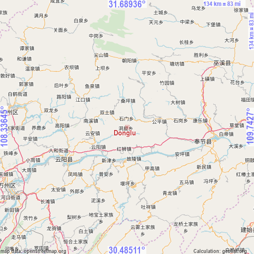
Donglu GPS coordinates[2]
31° 5' 20.904" North, 109° 2' 22.452" East
| Map corner | latitude | longitude |
|---|---|---|
| Upper-left | 31.68936°, | 108.33645° |
| Center: | 31.08914°, | 109.03957° |
| Lower-right: | 30.48511°, | 109.7427° |
| Map W x H: | 133.9×133.9 km | = 83.2×83.2mi |
| max Lat: | 53.31946° ⇑44.5% North |
| Donglu: | 31.08914° |
| min Lat: | ⇓55.5% South 18.22056° |
| min Long | Donglu | max Long |
| 75.07348° | 109.03957° | 134.28917° |
| W 23.9%⇐ | ⇒76.1% E |
Elevation
Elevation of Donglu is 795 m = 2608 ft, and this is 310.2 m = 1018 ft above average elevation for this country.
| Max E: |
5622 m = 18445 ft | 17.9% |
| Donglu | 795 m 2608 ft | |
| Avg. | 484.8 m = 1591 ft | |
Min E: |
-3 m = -10 ft | 82.1% |
See also: China elevation on elevation.city.
Geographical zone
Donglu is located in North temperate zone (between Tropic of Cancer and the Arctic Circle). Distance of this Northern Tropic circle is 850.9 km =528.7 mi to South.| Distance of | km | miles | from Donglu |
|---|---|---|---|
| North Pole | 6550.3 | 4070.2 | to North |
| Arctic Circle | 3944.4 | 2450.9 | to North |
| Tropic Cancer | 850.9 | 528.7 | to South |
| Equator | 3456.8 | 2148 | to South |


Nearby cities:
15 places around Donglu: (largest is in red/bold)
• Gongping
15.6 km =9.7 mi,  74°
74°
• Guling
16.9 km =10.5 mi,  166°
166°
• Hongshi
11.4 km =7.1 mi,  187°
187°
• Hongtu
6.8 km =4.2 mi,  54°
54°
• Jiagao
25.8 km =16 mi,  149°
149°
• Kangping
23.1 km =14.4 mi,  122°
122°
• Longdong
17.6 km =10.9 mi,  136°
136°
• Nanxi
19.5 km =12.1 mi,  277°
277°
• Pu’an
26.8 km =16.7 mi,  203°
203°
• Sangping
14.4 km =8.9 mi,  1°
1°
• Shimen
4.8 km =3 mi,  356°
356°
• Taiyang
8.7 km =5.4 mi,  341°
341°
• Xinzheng
17.8 km =11.1 mi,  22°
22°
• Yunyang
18.2 km =11.3 mi,  236°
236°
• Yun’an
18.4 km =11.4 mi,  254°
254°
Sources, notices
• [Note1] Compared only with cities in China existing in our database
• [Src1] Map data: © OpenStreetMap contributors (CC-BY-SA)
• [Src2] Other city data from geonames.org with taken over terms of usage.
• [Src3] Geographical zone / Annual Mean Temperature by Robert A. Rohde @ Wikipedia
