Gongping geodata
Gongping (Chongqing) is a seat of a fourth-order administrative division; located in China in Asia/Shanghai (GMT+8) time zone. In our database, there are 1268 cities with bigger population. Compared to other cities in China, 55.7% of cities are located further ↓South; 75.4% of cities are located further →East and 66.6% of cities have lower elevation than Gongping. Note1


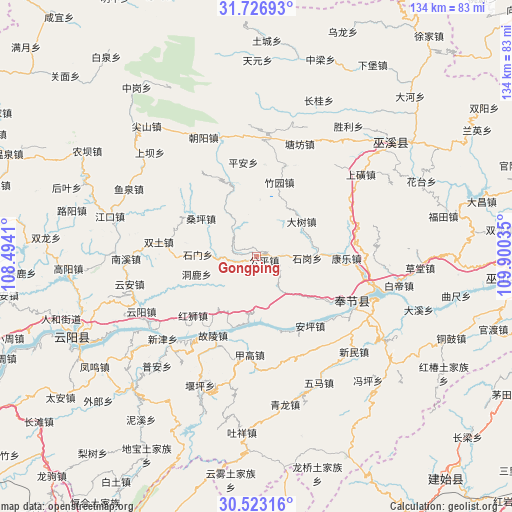
Gongping GPS coordinates[2]
31° 7' 37.02" North, 109° 11' 49.992" East
| Map corner | latitude | longitude |
|---|---|---|
| Upper-left | 31.72693°, | 108.4941° |
| Center: | 31.12695°, | 109.19722° |
| Lower-right: | 30.52316°, | 109.90035° |
| Map W x H: | 133.8×133.8 km | = 83.1×83.1mi |
| max Lat: | 53.31946° ⇑44.3% North |
| Gongping: | 31.12695° |
| min Lat: | ⇓55.7% South 18.22056° |
| min Long | Gongping | max Long |
| 75.07348° | 109.19722° | 134.28917° |
| W 24.6%⇐ | ⇒75.4% E |
Elevation
Elevation of Gongping is 354 m = 1161 ft, and this is 130.8 m = 429 ft below average elevation for this country.
| Max E: |
5622 m = 18445 ft | 33.4% |
| Avg. | 484.8 m = 1591 ft | |
| Gongping | 354 m = 1161 ft | |
Min E: |
-3 m = -10 ft | 66.6% |
See also: China elevation on elevation.city.
Geographical zone
Gongping is located in North temperate zone (between Tropic of Cancer and the Arctic Circle). Distance of this Northern Tropic circle is 855.1 km =531.3 mi to South.| Distance of | km | miles | from Gongping |
|---|---|---|---|
| North Pole | 6546.1 | 4067.6 | to North |
| Arctic Circle | 3940.2 | 2448.3 | to North |
| Tropic Cancer | 855.1 | 531.3 | to South |
| Equator | 3461 | 2150.6 | to South |


Nearby cities:
15 places around Gongping: (largest is in red/bold)
• Anping
23 km =14.3 mi,  142°
142°
• Dashu
15.1 km =9.4 mi,  51°
51°
• Donglu
15.6 km =9.7 mi,  254°
254°
• Guling
23.5 km =14.6 mi,  208°
208°
• Hongshi
22.6 km =14 mi,  226°
226°
• Hongtu
9.5 km =5.9 mi,  268°
268°
• Kangle
22.2 km =13.8 mi,  94°
94°
• Kangping
17.1 km =10.6 mi,  164°
164°
• Longdong
17.3 km =10.7 mi,  189°
189°
• Sangping
17.7 km =11 mi,  304°
304°
• Shigang
15.9 km =9.9 mi, 86°
• Shimen
15.3 km =9.5 mi, 272°
• Taiyang
18.3 km =11.4 mi,  282°
282°
• Xinzheng
14.8 km =9.2 mi,  326°
326°
• Zhuyuan
20.3 km =12.6 mi,  16°
16°
Sources, notices
• [Note1] Compared only with cities in China existing in our database
• [Src1] Map data: © OpenStreetMap contributors (CC-BY-SA)
• [Src2] Other city data from geonames.org with taken over terms of usage.
• [Src3] Geographical zone / Annual Mean Temperature by Robert A. Rohde @ Wikipedia
