Wenfu geodata
Wenfu (Chongqing) is a seat of a fourth-order administrative division; located in China in Asia/Shanghai (GMT+8) time zone. In our database, there are 1268 cities with bigger population. Compared to other cities in China, 62.3% of cities are located further ↑North; 80.7% of cities are located further →East and 82.5% of cities have lower elevation than Wenfu. Note1


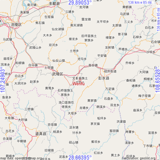
Wenfu GPS coordinates[2]
29° 16' 44.688" North, 107° 57' 7.74" East
| Map corner | latitude | longitude |
|---|---|---|
| Upper-left | 29.89053°, | 107.24903° |
| Center: | 29.27908°, | 107.95215° |
| Lower-right: | 28.66395°, | 108.65528° |
| Map W x H: | 136.4×136.4 km | = 84.8×84.8mi |
| max Lat: | 53.31946° ⇑62.3% North |
| Wenfu: | 29.27908° |
| min Lat: | ⇓37.7% South 18.22056° |
| min Long | Wenfu | max Long |
| 75.07348° | 107.95215° | 134.28917° |
| W 19.3%⇐ | ⇒80.7% E |
Elevation
Elevation of Wenfu is 821 m = 2694 ft, and this is 336.2 m = 1103 ft above average elevation for this country.
| Max E: |
5622 m = 18445 ft | 17.5% |
| Wenfu | 821 m 2694 ft | |
| Avg. | 484.8 m = 1591 ft | |
Min E: |
-3 m = -10 ft | 82.5% |
See also: China elevation on elevation.city.
Geographical zone
Wenfu is located in North temperate zone (between Tropic of Cancer and the Arctic Circle). Distance of this Northern Tropic circle is 649.6 km =403.6 mi to South.| Distance of | km | miles | from Wenfu |
|---|---|---|---|
| North Pole | 6751.5 | 4195.2 | to North |
| Arctic Circle | 4145.6 | 2576 | to North |
| Tropic Cancer | 649.6 | 403.6 | to South |
| Equator | 3255.5 | 2022.9 | to South |


Nearby cities:
15 places around Wenfu: (largest is in red/bold)
• Canggou
18.7 km =11.6 mi,  5°
5°
• Dianshui
13.3 km =8.3 mi,  87°
87°
• Gaogu
17 km =10.6 mi,  40°
40°
• Hanjia
20.4 km =12.7 mi,  84°
84°
• Haokou
23.8 km =14.8 mi,  209°
209°
• Huangjia
20 km =12.4 mi,  149°
149°
• Huolu
14.9 km =9.3 mi,  328°
328°
• Jiangkou
8.3 km =5.2 mi,  240°
240°
• Longtang
23.7 km =14.7 mi,  171°
171°
• Luwu
22.7 km =14.1 mi,  33°
33°
• Runxi
22.4 km =13.9 mi,  188°
188°
• Shiqiao
15 km =9.3 mi,  233°
233°
• Tudi
25.6 km =15.9 mi,  348°
348°
• Wanzu
26.4 km =16.4 mi,  106°
106°
• Xiangkou
21.6 km =13.4 mi,  285°
285°
Sources, notices
• [Note1] Compared only with cities in China existing in our database
• [Src1] Map data: © OpenStreetMap contributors (CC-BY-SA)
• [Src2] Other city data from geonames.org with taken over terms of usage.
• [Src3] Geographical zone / Annual Mean Temperature by Robert A. Rohde @ Wikipedia
