Gaotaizi geodata
Gaotaizi (Heilongjiang) is a seat of a fourth-order administrative division; located in China in Asia/Shanghai (GMT+8) time zone. In our database, there are 1268 cities with bigger population. Compared to other cities in China, 95.2% of cities are located further ↓South; 94.5% of cities are located further ←West and 54.4% of cities have higher elevation than Gaotaizi. Note1


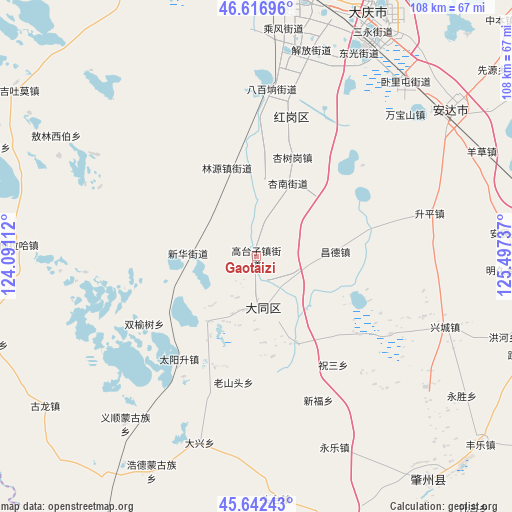
Gaotaizi GPS coordinates[2]
46° 7' 54.66" North, 124° 47' 39.264" East
| Map corner | latitude | longitude |
|---|---|---|
| Upper-left | 46.61696°, | 124.09112° |
| Center: | 46.13185°, | 124.79424° |
| Lower-right: | 45.64243°, | 125.49737° |
| Map W x H: | 108.4×108.4 km | = 67.4×67.4mi |
| max Lat: | 53.31946° ⇑4.8% North |
| Gaotaizi: | 46.13185° |
| min Lat: | ⇓95.2% South 18.22056° |
| min Long | Gaotaizi | max Long |
| 75.07348° | 124.79424° | 134.28917° |
| W 94.5%⇐ | ⇒5.5% E |
Elevation
Elevation of Gaotaizi is 135 m = 443 ft, and this is 349.8 m = 1148 ft below average elevation for this country.
| Max E: |
5622 m = 18445 ft | 54.4% |
| Avg. | 484.8 m = 1591 ft | |
| Gaotaizi | 135 m = 443 ft | |
Min E: |
-3 m = -10 ft | 45.6% |
See also: China elevation on elevation.city.
Geographical zone
Gaotaizi is located in North temperate zone (between Tropic of Cancer and the Arctic Circle). Distance of this North polar circle is 2271.8 km =1411.6 mi to North.| Distance of | km | miles | from Gaotaizi |
|---|---|---|---|
| North Pole | 4877.7 | 3030.9 | to North |
| Arctic Circle | 2271.8 | 1411.6 | to North |
| Tropic Cancer | 2523.5 | 1568 | to South |
| Equator | 5129.4 | 3187.3 | to South |


Nearby cities:
15 places around Gaotaizi: (largest is in red/bold)
• Anda
50 km =31.1 mi,  53°
53°
• Bajingzi
13.2 km =8.2 mi,  202°
202°
• Changde
17.1 km =10.6 mi,  86°
86°
• Daqing
52.6 km =32.7 mi,  17°
17°
• Datong
11 km =6.8 mi,  173°
173°
• Honggang
30.7 km =19.1 mi,  12°
12°
• Linyuan
20.6 km =12.8 mi,  341°
341°
• Longfeng
50.4 km =31.3 mi,  28°
28°
• Oroin Xibe
46.8 km =29.1 mi,  297°
297°
• Shengping
37.5 km =23.3 mi,  75°
75°
• Shuangyushu
14.7 km =9.1 mi,  272°
272°
• Talin Hiag
50.4 km =31.3 mi, 273°
• Wanbaoshan
42.8 km =26.6 mi, 47°
• Xinglongquan
16.8 km =10.4 mi,  305°
305°
• Xingshugang
22.2 km =13.8 mi, 19°
Sources, notices
• [Note1] Compared only with cities in China existing in our database
• [Src1] Map data: © OpenStreetMap contributors (CC-BY-SA)
• [Src2] Other city data from geonames.org with taken over terms of usage.
• [Src3] Geographical zone / Annual Mean Temperature by Robert A. Rohde @ Wikipedia
