Diaoguan geodata
Diaoguan (Hubei) is a seat of a fourth-order administrative division; located in China in Asia/Shanghai (GMT+8) time zone. In our database, there are 1268 cities with bigger population. Compared to other cities in China, 57.6% of cities are located further ↑North; 59.4% of cities are located further →East and 75.3% of cities have higher elevation than Diaoguan. Note1


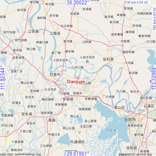
Diaoguan GPS coordinates[2]
29° 41' 28.572" North, 112° 37' 35.616" East
| Map corner | latitude | longitude |
|---|---|---|
| Upper-left | 30.30022°, | 111.92344° |
| Center: | 29.69127°, | 112.62656° |
| Lower-right: | 29.07861°, | 113.32969° |
| Map W x H: | 135.8×135.8 km | = 84.4×84.4mi |
| max Lat: | 53.31946° ⇑57.6% North |
| Diaoguan: | 29.69127° |
| min Lat: | ⇓42.4% South 18.22056° |
| min Long | Diaoguan | max Long |
| 75.07348° | 112.62656° | 134.28917° |
| W 40.6%⇐ | ⇒59.4% E |
Elevation
Elevation of Diaoguan is 36 m = 118 ft, and this is 448.8 m = 1472 ft below average elevation for this country.
| Max E: |
5622 m = 18445 ft | 75.3% |
| Avg. | 484.8 m = 1591 ft | |
| Diaoguan | 36 m = 118 ft | |
Min E: |
-3 m = -10 ft | 24.7% |
See also: China elevation on elevation.city.
Geographical zone
Diaoguan is located in North temperate zone (between Tropic of Cancer and the Arctic Circle). Distance of this Northern Tropic circle is 695.4 km =432.1 mi to South.| Distance of | km | miles | from Diaoguan |
|---|---|---|---|
| North Pole | 6705.7 | 4166.7 | to North |
| Arctic Circle | 4099.8 | 2547.5 | to North |
| Tropic Cancer | 695.4 | 432.1 | to South |
| Equator | 3301.4 | 2051.4 | to South |


Nearby cities:
15 places around Diaoguan: (largest is in red/bold)
• Chengji
27.3 km =17 mi,  1°
1°
• Dongsheng
10.4 km =6.5 mi,  285°
285°
• Gaojimiao
20.2 km =12.6 mi,  254°
254°
• Hengshi
24.6 km =15.3 mi,  342°
342°
• Hongcheng
30.5 km =19 mi,  56°
56°
• Huarong Chengguanzhen
20.6 km =12.8 mi,  201°
201°
• Jiaoshanhe
7.1 km =4.4 mi,  236°
236°
• Jiuheyuan
25.7 km =16 mi, 248°
• Nankou
29.3 km =18.2 mi,  283°
283°
• Ouchi
30.7 km =19.1 mi, 282°
• Renmindayuan
22 km =13.7 mi,  316°
316°
• Taohuashan
7.2 km =4.5 mi,  124°
124°
• Xiaohekou
9.7 km =6 mi,  356°
356°
• Xinchang
29.4 km =18.3 mi, 319°
• Xiulin
22.1 km =13.7 mi, 277°
Sources, notices
• [Note1] Compared only with cities in China existing in our database
• [Src1] Map data: © OpenStreetMap contributors (CC-BY-SA)
• [Src2] Other city data from geonames.org with taken over terms of usage.
• [Src3] Geographical zone / Annual Mean Temperature by Robert A. Rohde @ Wikipedia
