Chengbei geodata
Chengbei (Hubei) is a seat of a fourth-order administrative division; located in China in Asia/Shanghai (GMT+8) time zone. In our database, there are 1268 cities with bigger population. Compared to other cities in China, 54.5% of cities are located further ↓South; 53.9% of cities are located further →East and 78.3% of cities have higher elevation than Chengbei. Note1


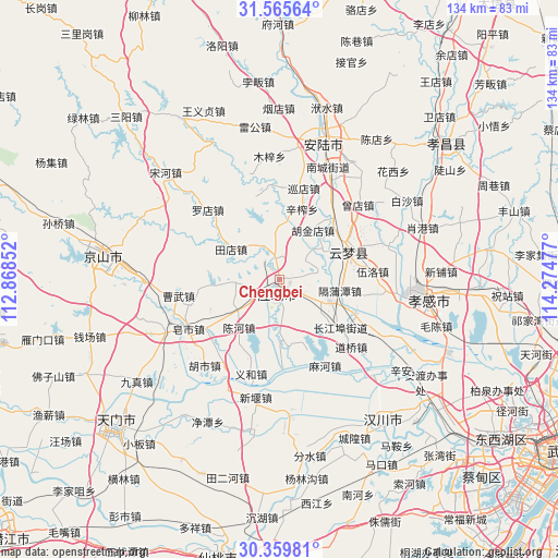
Chengbei GPS coordinates[2]
30° 57' 52.668" North, 113° 34' 17.904" East
| Map corner | latitude | longitude |
|---|---|---|
| Upper-left | 31.56564°, | 112.86852° |
| Center: | 30.96463°, | 113.57164° |
| Lower-right: | 30.35981°, | 114.27477° |
| Map W x H: | 134.1×134.1 km | = 83.3×83.3mi |
| max Lat: | 53.31946° ⇑45.5% North |
| Chengbei: | 30.96463° |
| min Lat: | ⇓54.5% South 18.22056° |
| min Long | Chengbei | max Long |
| 75.07348° | 113.57164° | 134.28917° |
| W 46.1%⇐ | ⇒53.9% E |
Elevation
Elevation of Chengbei is 30 m = 98 ft, and this is 454.8 m = 1492 ft below average elevation for this country.
| Max E: |
5622 m = 18445 ft | 78.3% |
| Avg. | 484.8 m = 1591 ft | |
| Chengbei | 30 m = 98 ft | |
Min E: |
-3 m = -10 ft | 21.7% |
See also: China elevation on elevation.city.
Geographical zone
Chengbei is located in North temperate zone (between Tropic of Cancer and the Arctic Circle). Distance of this Northern Tropic circle is 837 km =520.1 mi to South.| Distance of | km | miles | from Chengbei |
|---|---|---|---|
| North Pole | 6564.1 | 4078.7 | to North |
| Arctic Circle | 3958.2 | 2459.5 | to North |
| Tropic Cancer | 837 | 520.1 | to South |
| Equator | 3442.9 | 2139.3 | to South |


Nearby cities:
15 places around Chengbei: (largest is in red/bold)
• Changjiangbu
18.7 km =11.6 mi,  128°
128°
• Chengzhong
2.9 km =1.8 mi,  218°
218°
• Chenhe
15 km =9.3 mi, 219°
• Dongmafang
12.9 km =8 mi,  113°
113°
• Geputan
14.9 km =9.3 mi,  100°
100°
• Huangtan
6.8 km =4.2 mi,  180°
180°
• Hujindian
14.5 km =9 mi,  34°
34°
• Langjun
9.1 km =5.7 mi, 130°
• Langjun
12.1 km =7.5 mi, 127°
• Qingminghe
13.7 km =8.5 mi,  54°
54°
• Silipeng
4.4 km =2.7 mi,  119°
119°
• Tiandian
13.8 km =8.6 mi,  301°
301°
• Xinzha
17.8 km =11.1 mi,  18°
18°
• Yanghe
14.7 km =9.1 mi,  3°
3°
• Yangling
17.9 km =11.1 mi,  247°
247°
Sources, notices
• [Note1] Compared only with cities in China existing in our database
• [Src1] Map data: © OpenStreetMap contributors (CC-BY-SA)
• [Src2] Other city data from geonames.org with taken over terms of usage.
• [Src3] Geographical zone / Annual Mean Temperature by Robert A. Rohde @ Wikipedia
