Niuzhuang geodata
Niuzhuang (Hubei) is a seat of a fourth-order administrative division; located in China in Asia/Shanghai (GMT+8) time zone. In our database, there are 1268 cities with bigger population. Compared to other cities in China, 51.8% of cities are located further ↑North; 69.7% of cities are located further →East and 94% of cities have lower elevation than Niuzhuang. Note1


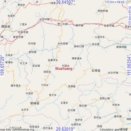
Niuzhuang GPS coordinates[2]
30° 14' 22.236" North, 110° 21' 37.476" East
| Map corner | latitude | longitude |
|---|---|---|
| Upper-left | 30.84507°, | 109.65729° |
| Center: | 30.23951°, | 110.36041° |
| Lower-right: | 29.63019°, | 111.06354° |
| Map W x H: | 135.1×135.1 km | = 83.9×83.9mi |
| max Lat: | 53.31946° ⇑51.8% North |
| Niuzhuang: | 30.23951° |
| min Lat: | ⇓48.2% South 18.22056° |
| min Long | Niuzhuang | max Long |
| 75.07348° | 110.36041° | 134.28917° |
| W 30.3%⇐ | ⇒69.7% E |
Elevation
Elevation of Niuzhuang is 1878 m = 6161 ft, and this is 1393.2 m = 4571 ft above average elevation for this country.
| Max E: |
5622 m = 18445 ft | 6% |
| Niuzhuang | 1878 m 6161 ft | |
| Avg. | 484.8 m = 1591 ft | |
Min E: |
-3 m = -10 ft | 94% |
See also: China elevation on elevation.city.
Geographical zone
Niuzhuang is located in North temperate zone (between Tropic of Cancer and the Arctic Circle). Distance of this Northern Tropic circle is 756.4 km =470 mi to South.| Distance of | km | miles | from Niuzhuang |
|---|---|---|---|
| North Pole | 6644.7 | 4128.8 | to North |
| Arctic Circle | 4038.9 | 2509.7 | to North |
| Tropic Cancer | 756.4 | 470 | to South |
| Equator | 3362.3 | 2089.2 | to South |


Nearby cities:
15 places around Niuzhuang: (largest is in red/bold)
• Caihua
8.9 km =5.5 mi,  107°
107°
• Fujiayan
13.8 km =8.6 mi,  55°
55°
• Guandian
30.4 km =18.9 mi,  270°
270°
• Jinguoping
14.5 km =9 mi,  293°
293°
• Jingyang
37.2 km =23.1 mi, 292°
• Majiagou
14.5 km =9 mi, 293°
• Qingtaiping
30.4 km =18.9 mi,  333°
333°
• Shangcunba
38 km =23.6 mi,  277°
277°
• Shuibuya
22.8 km =14.2 mi,  352°
352°
• Wantan
22.1 km =13.7 mi,  164°
164°
• Wufeng
32 km =19.9 mi,  97°
97°
• Wuyang
20.1 km =12.5 mi,  251°
251°
• Yanzi
33.1 km =20.6 mi,  204°
204°
• Yuxiakou
24.2 km =15 mi,  33°
33°
• Ziqiu
37.6 km =23.4 mi,  54°
54°
Sources, notices
• [Note1] Compared only with cities in China existing in our database
• [Src1] Map data: © OpenStreetMap contributors (CC-BY-SA)
• [Src2] Other city data from geonames.org with taken over terms of usage.
• [Src3] Geographical zone / Annual Mean Temperature by Robert A. Rohde @ Wikipedia
