Wuyang geodata
Wuyang (Hubei) is a seat of a fourth-order administrative division; located in China in Asia/Shanghai (GMT+8) time zone. In our database, there are 1268 cities with bigger population. Compared to other cities in China, 52.2% of cities are located further ↑North; 70.5% of cities are located further →East and 81.4% of cities have lower elevation than Wuyang. Note1


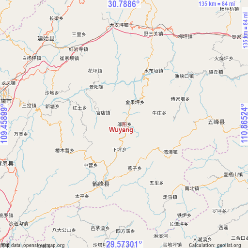
Wuyang GPS coordinates[2]
30° 10' 57.648" North, 110° 9' 43.596" East
| Map corner | latitude | longitude |
|---|---|---|
| Upper-left | 30.7886°, | 109.45899° |
| Center: | 30.18268°, | 110.16211° |
| Lower-right: | 29.57301°, | 110.86524° |
| Map W x H: | 135.2×135.2 km | = 84×84mi |
| max Lat: | 53.31946° ⇑52.2% North |
| Wuyang: | 30.18268° |
| min Lat: | ⇓47.8% South 18.22056° |
| min Long | Wuyang | max Long |
| 75.07348° | 110.16211° | 134.28917° |
| W 29.5%⇐ | ⇒70.5% E |
Elevation
Elevation of Wuyang is 762 m = 2500 ft, and this is 277.2 m = 909 ft above average elevation for this country.
| Max E: |
5622 m = 18445 ft | 18.6% |
| Wuyang | 762 m 2500 ft | |
| Avg. | 484.8 m = 1591 ft | |
Min E: |
-3 m = -10 ft | 81.4% |
See also: China elevation on elevation.city.
Geographical zone
Wuyang is located in North temperate zone (between Tropic of Cancer and the Arctic Circle). Distance of this Northern Tropic circle is 750.1 km =466.1 mi to South.| Distance of | km | miles | from Wuyang |
|---|---|---|---|
| North Pole | 6651.1 | 4132.8 | to North |
| Arctic Circle | 4045.2 | 2513.6 | to North |
| Tropic Cancer | 750.1 | 466.1 | to South |
| Equator | 3356 | 2085.3 | to South |


Nearby cities:
15 places around Wuyang: (largest is in red/bold)
• Caihua
27.8 km =17.3 mi,  82°
82°
• Fujiayan
33.5 km =20.8 mi,  65°
65°
• Guandian
13 km =8.1 mi,  299°
299°
• Hongtu
26.2 km =16.3 mi,  290°
290°
• Huaping
33.4 km =20.8 mi,  330°
330°
• Jinguoping
13.5 km =8.4 mi,  25°
25°
• Jingyang
25.7 km =16 mi,  323°
323°
• Majiagou
13.4 km =8.3 mi, 25°
• Niuzhuang
20.1 km =12.5 mi, 71°
• Qingtaiping
33.8 km =21 mi,  8°
8°
• Shangcunba
21.7 km =13.5 mi, 300°
• Shuibuya
33.1 km =20.6 mi, 29°
• Wantan
29.3 km =18.2 mi,  120°
120°
• Yanzi
24.5 km =15.2 mi,  166°
166°
• Zhongying
28.8 km =17.9 mi,  219°
219°
Sources, notices
• [Note1] Compared only with cities in China existing in our database
• [Src1] Map data: © OpenStreetMap contributors (CC-BY-SA)
• [Src2] Other city data from geonames.org with taken over terms of usage.
• [Src3] Geographical zone / Annual Mean Temperature by Robert A. Rohde @ Wikipedia
