Zhangcunping geodata
Zhangcunping (Hubei) is a seat of a fourth-order administrative division; located in China in Asia/Shanghai (GMT+8) time zone. In our database, there are 1268 cities with bigger population. Compared to other cities in China, 57% of cities are located further ↓South; 66.3% of cities are located further →East and 84.1% of cities have lower elevation than Zhangcunping. Note1


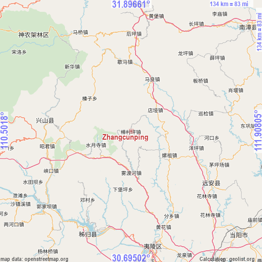
Zhangcunping GPS coordinates[2]
31° 17' 51.828" North, 111° 12' 17.712" East
| Map corner | latitude | longitude |
|---|---|---|
| Upper-left | 31.89661°, | 110.5018° |
| Center: | 31.29773°, | 111.20492° |
| Lower-right: | 30.69502°, | 111.90805° |
| Map W x H: | 133.6×133.6 km | = 83×83mi |
| max Lat: | 53.31946° ⇑43% North |
| Zhangcunping: | 31.29773° |
| min Lat: | ⇓57% South 18.22056° |
| min Long | Zhangcunping | max Long |
| 75.07348° | 111.20492° | 134.28917° |
| W 33.7%⇐ | ⇒66.3% E |
Elevation
Elevation of Zhangcunping is 922 m = 3025 ft, and this is 437.2 m = 1434 ft above average elevation for this country.
| Max E: |
5622 m = 18445 ft | 15.9% |
| Zhangcunping | 922 m 3025 ft | |
| Avg. | 484.8 m = 1591 ft | |
Min E: |
-3 m = -10 ft | 84.1% |
See also: China elevation on elevation.city.
Geographical zone
Zhangcunping is located in North temperate zone (between Tropic of Cancer and the Arctic Circle). Distance of this Northern Tropic circle is 874.1 km =543.1 mi to South.| Distance of | km | miles | from Zhangcunping |
|---|---|---|---|
| North Pole | 6527.1 | 4055.8 | to North |
| Arctic Circle | 3921.2 | 2436.5 | to North |
| Tropic Cancer | 874.1 | 543.1 | to South |
| Equator | 3480 | 2162.4 | to South |


Nearby cities:
15 places around Zhangcunping: (largest is in red/bold)
• Dianya
16.6 km =10.3 mi,  47°
47°
• Gaoyang
42.7 km =26.5 mi,  260°
260°
• Hehua
22.6 km =14 mi,  121°
121°
• Hekou
41.2 km =25.6 mi,  94°
94°
• Huangliang
36.2 km =22.5 mi, 264°
• Jianyangping
40 km =24.9 mi,  242°
242°
• Jiuxian
43 km =26.7 mi, 117°
• Maliang
28.9 km =18 mi,  21°
21°
• Shuiyuesi
19.3 km =12 mi,  250°
250°
• Wuduhe
21 km =13 mi,  179°
179°
• Xiabaoping
29.8 km =18.5 mi,  188°
188°
• Xiema
35.8 km =22.2 mi,  354°
354°
• Xunjian
39.8 km =24.7 mi,  75°
75°
• Yangping
34.1 km =21.2 mi,  103°
103°
• Zhenzi
27.5 km =17.1 mi,  308°
308°
Sources, notices
• [Note1] Compared only with cities in China existing in our database
• [Src1] Map data: © OpenStreetMap contributors (CC-BY-SA)
• [Src2] Other city data from geonames.org with taken over terms of usage.
• [Src3] Geographical zone / Annual Mean Temperature by Robert A. Rohde @ Wikipedia
