Hongjunlu geodata
Hongjunlu (Heilongjiang) is a seat of a third-order administrative division; located in China in Asia/Shanghai (GMT+8) time zone. In our database, there are 1268 cities with bigger population. Compared to other cities in China, 94.2% of cities are located further ↓South; 99.9% of cities are located further ←West and 53.5% of cities have lower elevation than Hongjunlu. Note1


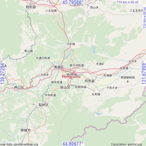
Hongjunlu GPS coordinates[2]
45° 18' 12.492" North, 130° 58' 33.456" East
| Map corner | latitude | longitude |
|---|---|---|
| Upper-left | 45.79586°, | 130.27284° |
| Center: | 45.30347°, | 130.97596° |
| Lower-right: | 44.80677°, | 131.67909° |
| Map W x H: | 110×110 km | = 68.4×68.4mi |
| max Lat: | 53.31946° ⇑5.8% North |
| Hongjunlu: | 45.30347° |
| min Lat: | ⇓94.2% South 18.22056° |
| min Long | Hongjunlu | max Long |
| 75.07348° | 130.97596° | 134.28917° |
| W 99.9%⇐ | ⇒0.099999999999994% E |
Elevation
Elevation of Hongjunlu is 193 m = 633 ft, and this is 291.8 m = 957 ft below average elevation for this country.
| Max E: |
5622 m = 18445 ft | 46.5% |
| Avg. | 484.8 m = 1591 ft | |
| Hongjunlu | 193 m = 633 ft | |
Min E: |
-3 m = -10 ft | 53.5% |
See also: China elevation on elevation.city.
Geographical zone
Hongjunlu is located in North temperate zone (between Tropic of Cancer and the Arctic Circle). Distance of this North polar circle is 2363.9 km =1468.9 mi to North.| Distance of | km | miles | from Hongjunlu |
|---|---|---|---|
| North Pole | 4969.8 | 3088.1 | to North |
| Arctic Circle | 2363.9 | 1468.9 | to North |
| Tropic Cancer | 2431.4 | 1510.8 | to South |
| Equator | 5037.3 | 3130 | to South |


Nearby cities:
15 places around Hongjunlu: (largest is in red/bold)
• Chengzihe
7.8 km =4.8 mi,  64°
64°
• Didaohe
11.7 km =7.3 mi,  296°
296°
• Dongxing
16.1 km =10 mi,  293°
293°
• Fendou
11.6 km =7.2 mi,  209°
209°
• Hongqi
10.9 km =6.8 mi,  201°
201°
• Hongxing
3.5 km =2.2 mi, 200°
• Jidong
12.8 km =8 mi,  138°
138°
• Jixi
1.5 km =0.9 mi,  259°
259°
• Kuishan
46.1 km =28.6 mi, 259°
• Lanling
21.6 km =13.4 mi,  267°
267°
• Lishu
32.6 km =20.3 mi,  223°
223°
• Mashan
36.9 km =22.9 mi,  252°
252°
• Xijiao
2.9 km =1.8 mi,  308°
308°
• Xingnong
22.1 km =13.7 mi,  353°
353°
• Yahe
44.1 km =27.4 mi,  283°
283°
Sources, notices
• [Note1] Compared only with cities in China existing in our database
• [Src1] Map data: © OpenStreetMap contributors (CC-BY-SA)
• [Src2] Other city data from geonames.org with taken over terms of usage.
• [Src3] Geographical zone / Annual Mean Temperature by Robert A. Rohde @ Wikipedia
