Mazongshan geodata
Mazongshan (Inner Mongolia) is a seat of a fourth-order administrative division; located in China in Asia/Shanghai (GMT+8) time zone. In our database, there are 1268 cities with bigger population. Compared to other cities in China, 89.1% of cities are located further ↓South; 95.3% of cities are located further →East and 90.7% of cities have lower elevation than Mazongshan. Note1


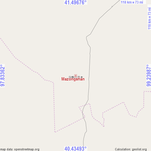
Mazongshan GPS coordinates[2]
40° 58' 4.728" North, 98° 32' 12.264" East
| Map corner | latitude | longitude |
|---|---|---|
| Upper-left | 41.49676°, | 97.83362° |
| Center: | 40.96798°, | 98.53674° |
| Lower-right: | 40.43493°, | 99.23987° |
| Map W x H: | 118.1×118.1 km | = 73.4×73.4mi |
| max Lat: | 53.31946° ⇑10.9% North |
| Mazongshan: | 40.96798° |
| min Lat: | ⇓89.1% South 18.22056° |
| min Long | Mazongshan | max Long |
| 75.07348° | 98.53674° | 134.28917° |
| W 4.7%⇐ | ⇒95.3% E |
Elevation
Elevation of Mazongshan is 1427 m = 4682 ft, and this is 942.2 m = 3091 ft above average elevation for this country.
| Max E: |
5622 m = 18445 ft | 9.3% |
| Mazongshan | 1427 m 4682 ft | |
| Avg. | 484.8 m = 1591 ft | |
Min E: |
-3 m = -10 ft | 90.7% |
See also: China elevation on elevation.city.
Geographical zone
Mazongshan is located in North temperate zone (between Tropic of Cancer and the Arctic Circle). Distance of this Northern Tropic circle is 1949.3 km =1211.2 mi to South.| Distance of | km | miles | from Mazongshan |
|---|---|---|---|
| North Pole | 5451.8 | 3387.6 | to North |
| Arctic Circle | 2846 | 1768.4 | to North |
| Tropic Cancer | 1949.3 | 1211.2 | to South |
| Equator | 4555.2 | 2830.5 | to South |


Nearby cities:
15 places around Mazongshan: (largest is in red/bold)
• Dongba
96.8 km =60.1 mi,  155°
155°
• Gucheng
96.3 km =59.8 mi, 163°
• Huahai
100.1 km =62.2 mi,  222°
222°
• Jiayuguan
130.4 km =81 mi,  189°
189°
• Jiji
116.9 km =72.6 mi,  141°
141°
• Jinta
112.8 km =70.1 mi, 164°
• Jinta
113 km =70.2 mi,  165°
165°
• Jiuquan
136.2 km =84.6 mi,  180°
180°
• Linshui
132.8 km =82.5 mi, 170°
• Sanhe
101.8 km =63.3 mi, 160°
• Xiaxihao
139.8 km =86.9 mi,  238°
238°
• Xiba
91.2 km =56.7 mi, 168°
• Yangjingziwan
112.1 km =69.7 mi, 159°
• Yumen
136.1 km =84.6 mi, 235°
• Zhongdong
97.3 km =60.5 mi, 165°
Sources, notices
• [Note1] Compared only with cities in China existing in our database
• [Src1] Map data: © OpenStreetMap contributors (CC-BY-SA)
• [Src2] Other city data from geonames.org with taken over terms of usage.
• [Src3] Geographical zone / Annual Mean Temperature by Robert A. Rohde @ Wikipedia
