Qingchuan geodata
Qingchuan (Heilongjiang) is a seat of a fourth-order administrative division; located in China in Asia/Shanghai (GMT+8) time zone. In our database, there are 1268 cities with bigger population. Compared to other cities in China, 94.3% of cities are located further ↓South; 98% of cities are located further ←West and 52.5% of cities have lower elevation than Qingchuan. Note1


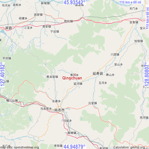
Qingchuan GPS coordinates[2]
45° 26' 39.336" North, 128° 6' 17.784" East
| Map corner | latitude | longitude |
|---|---|---|
| Upper-left | 45.93542°, | 127.40182° |
| Center: | 45.44426°, | 128.10494° |
| Lower-right: | 44.94879°, | 128.80807° |
| Map W x H: | 109.7×109.7 km | = 68.2×68.2mi |
| max Lat: | 53.31946° ⇑5.7% North |
| Qingchuan: | 45.44426° |
| min Lat: | ⇓94.3% South 18.22056° |
| min Long | Qingchuan | max Long |
| 75.07348° | 128.10494° | 134.28917° |
| W 98%⇐ | ⇒2% E |
Elevation
Elevation of Qingchuan is 184 m = 604 ft, and this is 300.8 m = 987 ft below average elevation for this country.
| Max E: |
5622 m = 18445 ft | 47.5% |
| Avg. | 484.8 m = 1591 ft | |
| Qingchuan | 184 m = 604 ft | |
Min E: |
-3 m = -10 ft | 52.5% |
See also: China elevation on elevation.city.
Geographical zone
Qingchuan is located in North temperate zone (between Tropic of Cancer and the Arctic Circle). Distance of this North polar circle is 2348.2 km =1459.1 mi to North.| Distance of | km | miles | from Qingchuan |
|---|---|---|---|
| North Pole | 4954.1 | 3078.3 | to North |
| Arctic Circle | 2348.2 | 1459.1 | to North |
| Tropic Cancer | 2447 | 1520.5 | to South |
| Equator | 5052.9 | 3139.7 | to South |


Nearby cities:
15 places around Qingchuan: (largest is in red/bold)
• Anshan
33.2 km =20.6 mi,  76°
76°
• Changshou
23.6 km =14.7 mi,  214°
214°
• Guang’en
31.9 km =19.8 mi,  315°
315°
• Hedong
21.6 km =13.4 mi,  195°
195°
• Heilonggong
16.3 km =10.1 mi,  264°
264°
• Liutuan
33.3 km =20.7 mi,  63°
63°
• Ningyuan
35.1 km =21.8 mi,  335°
335°
• Shangzhi
27.6 km =17.1 mi, 201°
• Shengli
39.8 km =24.7 mi,  353°
353°
• Shoushan
26.1 km =16.2 mi,  89°
89°
• Wujimi
32.7 km =20.3 mi,  219°
219°
• Yanhe
6.8 km =4.2 mi,  158°
158°
• Yanshou
17.3 km =10.7 mi, 86°
• Yuanbao
24.6 km =15.3 mi,  147°
147°
• Yuhe
21.4 km =13.3 mi,  105°
105°
Sources, notices
• [Note1] Compared only with cities in China existing in our database
• [Src1] Map data: © OpenStreetMap contributors (CC-BY-SA)
• [Src2] Other city data from geonames.org with taken over terms of usage.
• [Src3] Geographical zone / Annual Mean Temperature by Robert A. Rohde @ Wikipedia
