Yuanbao geodata
Yuanbao (Heilongjiang) is a seat of a fourth-order administrative division; located in China in Asia/Shanghai (GMT+8) time zone. In our database, there are 1268 cities with bigger population. Compared to other cities in China, 94.1% of cities are located further ↓South; 98.1% of cities are located further ←West and 51.5% of cities have lower elevation than Yuanbao. Note1


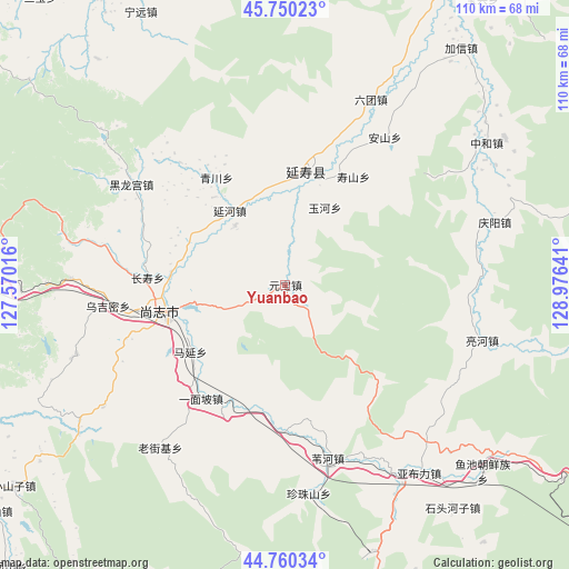
Yuanbao GPS coordinates[2]
45° 15' 26.784" North, 128° 16' 23.808" East
| Map corner | latitude | longitude |
|---|---|---|
| Upper-left | 45.75023°, | 127.57016° |
| Center: | 45.25744°, | 128.27328° |
| Lower-right: | 44.76034°, | 128.97641° |
| Map W x H: | 110.1×110.1 km | = 68.4×68.4mi |
| max Lat: | 53.31946° ⇑5.9% North |
| Yuanbao: | 45.25744° |
| min Lat: | ⇓94.1% South 18.22056° |
| min Long | Yuanbao | max Long |
| 75.07348° | 128.27328° | 134.28917° |
| W 98.1%⇐ | ⇒1.9% E |
Elevation
Elevation of Yuanbao is 177 m = 581 ft, and this is 307.8 m = 1010 ft below average elevation for this country.
| Max E: |
5622 m = 18445 ft | 48.5% |
| Avg. | 484.8 m = 1591 ft | |
| Yuanbao | 177 m = 581 ft | |
Min E: |
-3 m = -10 ft | 51.5% |
See also: China elevation on elevation.city.
Geographical zone
Yuanbao is located in North temperate zone (between Tropic of Cancer and the Arctic Circle). Distance of this North polar circle is 2369 km =1472 mi to North.| Distance of | km | miles | from Yuanbao |
|---|---|---|---|
| North Pole | 4974.9 | 3091.3 | to North |
| Arctic Circle | 2369 | 1472 | to North |
| Tropic Cancer | 2426.2 | 1507.6 | to South |
| Equator | 5032.2 | 3126.9 | to South |


Nearby cities:
15 places around Yuanbao: (largest is in red/bold)
• Anshan
34.2 km =21.3 mi,  34°
34°
• Changshou
26.7 km =16.6 mi,  272°
272°
• Hedong
19 km =11.8 mi, 269°
• Heilonggong
35.2 km =21.9 mi,  303°
303°
• Laojieji
40.1 km =24.9 mi,  217°
217°
• Lianghe
39.7 km =24.7 mi,  105°
105°
• Liutuan
39.3 km =24.4 mi, 25°
• Qingchuan
24.6 km =15.3 mi,  327°
327°
• Shangzhi
23.9 km =14.9 mi,  258°
258°
• Shoushan
24.7 km =15.3 mi, 31°
• Weihe
34.6 km =21.5 mi,  166°
166°
• Wujimi
34.5 km =21.4 mi, 262°
• Yanhe
18 km =11.2 mi,  323°
323°
• Yanshou
22.2 km =13.8 mi,  10°
10°
• Yuhe
16.8 km =10.4 mi, 26°
Sources, notices
• [Note1] Compared only with cities in China existing in our database
• [Src1] Map data: © OpenStreetMap contributors (CC-BY-SA)
• [Src2] Other city data from geonames.org with taken over terms of usage.
• [Src3] Geographical zone / Annual Mean Temperature by Robert A. Rohde @ Wikipedia
