Yuhe geodata
Yuhe (Heilongjiang) is a seat of a fourth-order administrative division; located in China in Asia/Shanghai (GMT+8) time zone. In our database, there are 1268 cities with bigger population. Compared to other cities in China, 94.3% of cities are located further ↓South; 98.1% of cities are located further ←West and 51.3% of cities have lower elevation than Yuhe. Note1


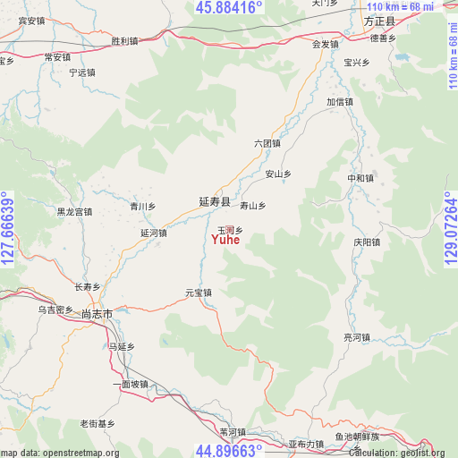
Yuhe GPS coordinates[2]
45° 23' 33.18" North, 128° 22' 10.236" East
| Map corner | latitude | longitude |
|---|---|---|
| Upper-left | 45.88416°, | 127.66639° |
| Center: | 45.39255°, | 128.36951° |
| Lower-right: | 44.89663°, | 129.07264° |
| Map W x H: | 109.8×109.8 km | = 68.2×68.2mi |
| max Lat: | 53.31946° ⇑5.7% North |
| Yuhe: | 45.39255° |
| min Lat: | ⇓94.3% South 18.22056° |
| min Long | Yuhe | max Long |
| 75.07348° | 128.36951° | 134.28917° |
| W 98.1%⇐ | ⇒1.9% E |
Elevation
Elevation of Yuhe is 175 m = 574 ft, and this is 309.8 m = 1016 ft below average elevation for this country.
| Max E: |
5622 m = 18445 ft | 48.7% |
| Avg. | 484.8 m = 1591 ft | |
| Yuhe | 175 m = 574 ft | |
Min E: |
-3 m = -10 ft | 51.3% |
See also: China elevation on elevation.city.
Geographical zone
Yuhe is located in North temperate zone (between Tropic of Cancer and the Arctic Circle). Distance of this North polar circle is 2354 km =1462.7 mi to North.| Distance of | km | miles | from Yuhe |
|---|---|---|---|
| North Pole | 4959.9 | 3081.9 | to North |
| Arctic Circle | 2354 | 1462.7 | to North |
| Tropic Cancer | 2441.3 | 1517 | to South |
| Equator | 5047.2 | 3136.2 | to South |


Nearby cities:
15 places around Yuhe: (largest is in red/bold)
• Anshan
17.7 km =11 mi,  41°
41°
• Changshou
36.8 km =22.9 mi,  248°
248°
• Hedong
30.5 km =19 mi,  240°
240°
• Heilonggong
37.1 km =23.1 mi,  276°
276°
• Lianghe
40.1 km =24.9 mi,  130°
130°
• Liutuan
22.5 km =14 mi,  23°
23°
• Qingchuan
21.4 km =13.3 mi,  285°
285°
• Qingyang
33.1 km =20.6 mi,  95°
95°
• Shangzhi
36.7 km =22.8 mi, 237°
• Shanhecun
39.1 km =24.3 mi, 24°
• Shoushan
8.1 km =5 mi, 42°
• Yanhe
18.2 km =11.3 mi,  268°
268°
• Yanshou
7.5 km =4.7 mi,  333°
333°
• Yuanbao
16.8 km =10.4 mi,  206°
206°
• Zhonghe
33.8 km =21 mi,  68°
68°
Sources, notices
• [Note1] Compared only with cities in China existing in our database
• [Src1] Map data: © OpenStreetMap contributors (CC-BY-SA)
• [Src2] Other city data from geonames.org with taken over terms of usage.
• [Src3] Geographical zone / Annual Mean Temperature by Robert A. Rohde @ Wikipedia
