Taiping geodata
Taiping (Jiangsu) is a seat of a fourth-order administrative division; located in China in Asia/Shanghai (GMT+8) time zone. In our database, there are 1268 cities with bigger population. Compared to other cities in China, 58% of cities are located further ↓South; 86.2% of cities are located further ←West and 97.2% of cities have higher elevation than Taiping. Note1


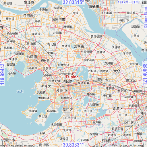
Taiping GPS coordinates[2]
31° 26' 6.54" North, 120° 41' 51.18" East
| Map corner | latitude | longitude |
|---|---|---|
| Upper-left | 32.03315°, | 119.99443° |
| Center: | 31.43515°, | 120.69755° |
| Lower-right: | 30.83331°, | 121.40068° |
| Map W x H: | 133.4×133.4 km | = 82.9×82.9mi |
| max Lat: | 53.31946° ⇑42% North |
| Taiping: | 31.43515° |
| min Lat: | ⇓58% South 18.22056° |
| min Long | Taiping | max Long |
| 75.07348° | 120.69755° | 134.28917° |
| W 86.2%⇐ | ⇒13.8% E |
Elevation
Elevation of Taiping is 5 m = 16 ft, and this is 479.8 m = 1574 ft below average elevation for this country.
| Max E: |
5622 m = 18445 ft | 97.2% |
| Avg. | 484.8 m = 1591 ft | |
| Taiping | 5 m = 16 ft | |
Min E: |
-3 m = -10 ft | 2.8% |
See also: China elevation on elevation.city.
Geographical zone
Taiping is located in North temperate zone (between Tropic of Cancer and the Arctic Circle). Distance of this Northern Tropic circle is 889.3 km =552.6 mi to South.| Distance of | km | miles | from Taiping |
|---|---|---|---|
| North Pole | 6511.8 | 4046.2 | to North |
| Arctic Circle | 3905.9 | 2427 | to North |
| Tropic Cancer | 889.3 | 552.6 | to South |
| Equator | 3495.3 | 2171.9 | to South |


Nearby cities:
15 places around Taiping: (largest is in red/bold)
• Bacheng
16.8 km =10.4 mi,  81°
81°
• Baiyangwan
17.6 km =10.9 mi,  236°
236°
• Beiqiao
12.7 km =7.9 mi,  310°
310°
• Ehu
17.8 km =11.1 mi,  304°
304°
• Huangdai
13.4 km =8.3 mi,  270°
270°
• Loufeng
16.5 km =10.3 mi,  192°
192°
• Pingjianglu
14.9 km =9.3 mi,  205°
205°
• Shilu
16.9 km =10.5 mi,  215°
215°
• Shuangta
15.9 km =9.9 mi,  203°
203°
• Suzhou
17.5 km =10.9 mi, 213°
• Weitang
6 km =3.7 mi, 303°
• Weiting
9.9 km =6.2 mi,  181°
181°
• Xinzhuang
11.4 km =7.1 mi,  355°
355°
• Yangdenghu
6.9 km =4.3 mi,  20°
20°
• Yuanhe
8.8 km =5.5 mi, 243°
Sources, notices
• [Note1] Compared only with cities in China existing in our database
• [Src1] Map data: © OpenStreetMap contributors (CC-BY-SA)
• [Src2] Other city data from geonames.org with taken over terms of usage.
• [Src3] Geographical zone / Annual Mean Temperature by Robert A. Rohde @ Wikipedia
