Nuanquan geodata
Nuanquan (Inner Mongolia) is a seat of a fourth-order administrative division; located in China in Asia/Shanghai (GMT+8) time zone. In our database, there are 1268 cities with bigger population. Compared to other cities in China, 85.3% of cities are located further ↓South; 63.9% of cities are located further →East and 91.2% of cities have lower elevation than Nuanquan. Note1


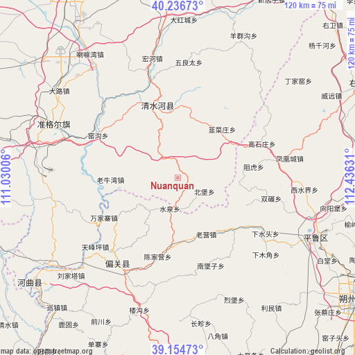
Nuanquan GPS coordinates[2]
39° 41' 52.26" North, 111° 43' 59.448" East
| Map corner | latitude | longitude |
|---|---|---|
| Upper-left | 40.23673°, | 111.03006° |
| Center: | 39.69785°, | 111.73318° |
| Lower-right: | 39.15473°, | 112.43631° |
| Map W x H: | 120.3×120.3 km | = 74.8×74.8mi |
| max Lat: | 53.31946° ⇑14.7% North |
| Nuanquan: | 39.69785° |
| min Lat: | ⇓85.3% South 18.22056° |
| min Long | Nuanquan | max Long |
| 75.07348° | 111.73318° | 134.28917° |
| W 36.1%⇐ | ⇒63.9% E |
Elevation
Elevation of Nuanquan is 1479 m = 4852 ft, and this is 994.2 m = 3262 ft above average elevation for this country.
| Max E: |
5622 m = 18445 ft | 8.8% |
| Nuanquan | 1479 m 4852 ft | |
| Avg. | 484.8 m = 1591 ft | |
Min E: |
-3 m = -10 ft | 91.2% |
See also: China elevation on elevation.city.
Geographical zone
Nuanquan is located in North temperate zone (between Tropic of Cancer and the Arctic Circle). Distance of this Northern Tropic circle is 1808.1 km =1123.5 mi to South.| Distance of | km | miles | from Nuanquan |
|---|---|---|---|
| North Pole | 5593.1 | 3475.4 | to North |
| Arctic Circle | 2987.2 | 1856.2 | to North |
| Tropic Cancer | 1808.1 | 1123.5 | to South |
| Equator | 4414 | 2742.7 | to South |


Nearby cities:
15 places around Nuanquan: (largest is in red/bold)
• Beibao
10.3 km =6.4 mi,  120°
120°
• Chengguan
23.8 km =14.8 mi,  347°
347°
• Dongmugou
28.2 km =17.5 mi,  308°
308°
• Fenghuangcheng
38.4 km =23.9 mi,  80°
80°
• Hougaoshizhuang
33 km =20.5 mi,  64°
64°
• Jiucaizhuang
21.6 km =13.4 mi,  42°
42°
• Pendiqing
35.6 km =22.1 mi, 40°
• Shantaizi
23.4 km =14.5 mi,  266°
266°
• Shuangnian
32.2 km =20 mi,  102°
102°
• Xiaomiaozi
25.4 km =15.8 mi,  344°
344°
• Xiashuitou
35.4 km =22 mi, 122°
• Xinguan
32.1 km =19.9 mi,  212°
212°
• Yangjiayao
30.7 km =19.1 mi,  10°
10°
• Yaogou
28.8 km =17.9 mi,  296°
296°
• Zuhu
25.7 km =16 mi, 81°
Sources, notices
• [Note1] Compared only with cities in China existing in our database
• [Src1] Map data: © OpenStreetMap contributors (CC-BY-SA)
• [Src2] Other city data from geonames.org with taken over terms of usage.
• [Src3] Geographical zone / Annual Mean Temperature by Robert A. Rohde @ Wikipedia
