Zhongyu geodata
Zhongyu (Tibet) is a seat of a fourth-order administrative division; located in China in Asia/Shanghai (GMT+8) time zone. In our database, there are 1268 cities with bigger population. Compared to other cities in China, 50.3% of cities are located further ↓South; 96.4% of cities are located further →East and 97.6% of cities have lower elevation than Zhongyu. Note1


Zhongyu GPS coordinates[2]
30° 29' 24.54" North, 94° 0' 20.052" East
| Map corner | latitude | longitude |
|---|---|---|
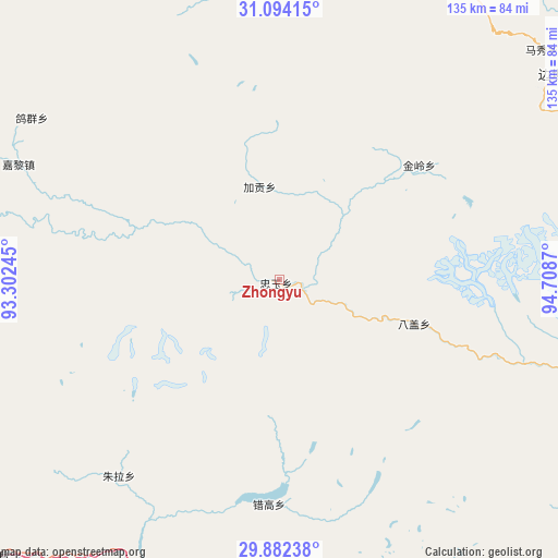
| Upper-left | 31.09415°, | 93.30245° |
| Center: | 30.49015°, | 94.00557° |
| Lower-right: | 29.88238°, | 94.7087° |
| Map W x H: | 134.7×134.7 km | = 83.7×83.7mi |
| max Lat: | 53.31946° ⇑49.7% North |
| Zhongyu: | 30.49015° |
| min Lat: | ⇓50.3% South 18.22056° |
| min Long | Zhongyu | max Long |
| 75.07348° | 94.00557° | 134.28917° |
| W 3.6%⇐ | ⇒96.4% E |
Elevation
Elevation of Zhongyu is 3405 m = 11171 ft, and this is 2920.2 m = 9581 ft above average elevation for this country.
| Max E: |
5622 m = 18445 ft | 2.4% |
| Zhongyu | 3405 m 11171 ft | |
| Avg. | 484.8 m = 1591 ft | |
Min E: |
-3 m = -10 ft | 97.6% |
See also: China elevation on elevation.city.
Geographical zone
Zhongyu is located in North temperate zone (between Tropic of Cancer and the Arctic Circle). Distance of this Northern Tropic circle is 784.3 km =487.3 mi to South.| Distance of | km | miles | from Zhongyu |
|---|---|---|---|
| North Pole | 6616.9 | 4111.5 | to North |
| Arctic Circle | 4011 | 2492.3 | to North |
| Tropic Cancer | 784.3 | 487.3 | to South |
| Equator | 3390.2 | 2106.6 | to South |


Nearby cities:
15 places around Zhongyu: (largest is in red/bold)
• Arza
75 km =46.6 mi,  283°
283°
• Baiba
78.2 km =48.6 mi,  190°
190°
• Banbar
88.1 km =54.7 mi,  64°
64°
• Coka
78.5 km =48.8 mi,  53°
53°
• Domartang
82.2 km =51.1 mi, 52°
• Gengzhang
85.2 km =52.9 mi,  174°
174°
• Goqung
71.8 km =44.6 mi,  303°
303°
• Jaggong
23.4 km =14.5 mi,  347°
347°
• Jiling
43.9 km =27.3 mi, 52°
• Lhari
69.9 km =43.4 mi,  293°
293°
• Marxog
83.2 km =51.7 mi, 48°
• Nyinmo
90.1 km =56 mi,  20°
20°
• Paingar
78.7 km =48.9 mi,  2°
2°
• Xarlung
94.4 km =58.7 mi,  225°
225°
• Yangxoi
80.1 km =49.8 mi,  357°
357°
Sources, notices
• [Note1] Compared only with cities in China existing in our database
• [Src1] Map data: © OpenStreetMap contributors (CC-BY-SA)
• [Src2] Other city data from geonames.org with taken over terms of usage.
• [Src3] Geographical zone / Annual Mean Temperature by Robert A. Rohde @ Wikipedia
