Ailan Mubage geodata
Ailan Mubage (Xinjiang) is a seat of a third-order administrative division; located in China in Asia/Urumqi (GMT+6) time zone. In our database, there are 1268 cities with bigger population. Compared to other cities in China, 92.6% of cities are located further ↓South; 99.3% of cities are located further →East and 78.7% of cities have lower elevation than Ailan Mubage. Note1


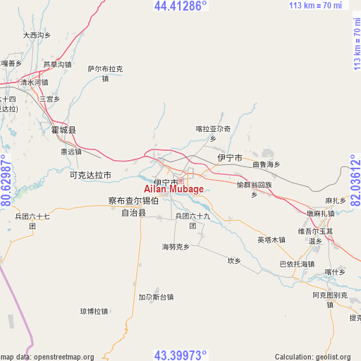
Ailan Mubage GPS coordinates[2]
43° 54' 30.42" North, 81° 19' 58.764" East
| Map corner | latitude | longitude |
|---|---|---|
| Upper-left | 44.41286°, | 80.62987° |
| Center: | 43.90845°, | 81.33299° |
| Lower-right: | 43.39973°, | 82.03612° |
| Map W x H: | 112.6×112.6 km | = 70×70mi |
| max Lat: | 53.31946° ⇑7.4% North |
| Ailan Mubage: | 43.90845° |
| min Lat: | ⇓92.6% South 18.22056° |
| min Long | Ailan Mubage | max Long |
| 75.07348° | 81.33299° | 134.28917° |
| W 0.7%⇐ | ⇒99.3% E |
Elevation
Elevation of Ailan Mubage is 643 m = 2110 ft, and this is 158.2 m = 519 ft above average elevation for this country.
| Max E: |
5622 m = 18445 ft | 21.3% |
| Ailan Mubage | 643 m 2110 ft | |
| Avg. | 484.8 m = 1591 ft | |
Min E: |
-3 m = -10 ft | 78.7% |
See also: China elevation on elevation.city.
Geographical zone
Ailan Mubage is located in North temperate zone (between Tropic of Cancer and the Arctic Circle). Distance of this Northern Tropic circle is 2276.2 km =1414.4 mi to South.| Distance of | km | miles | from Ailan Mubage |
|---|---|---|---|
| North Pole | 5124.9 | 3184.5 | to North |
| Arctic Circle | 2519 | 1565.2 | to North |
| Tropic Cancer | 2276.2 | 1414.4 | to South |
| Equator | 4882.2 | 3033.7 | to South |


Nearby cities:
15 places around Ailan Mubage: (largest is in red/bold)
• Dadamtu
8.1 km =5 mi,  349°
349°
• Huiyuan
39 km =24.2 mi,  277°
277°
• Huocheng
40.3 km =25 mi,  293°
293°
• Jagistay
37.8 km =23.5 mi,  193°
193°
• Kan
31.4 km =19.5 mi,  147°
147°
• Onyar
36.6 km =22.7 mi,  100°
100°
• Qapqal
23 km =14.3 mi,  238°
238°
• Sadikyüzi
18 km =11.2 mi,  83°
83°
• Taxkowrük
2.8 km =1.7 mi,  230°
230°
• Turpanyüzi
15.4 km =9.6 mi,  49°
49°
• Yengitam
31.7 km =19.7 mi,  124°
124°
• Yengiyar
15.6 km =9.7 mi, 294°
• Yili
1.7 km =1.1 mi, 124°
• Yining
16.7 km =10.4 mi,  62°
62°
• Yuqunweng
23.4 km =14.5 mi, 99°
Sources, notices
• [Note1] Compared only with cities in China existing in our database
• [Src1] Map data: © OpenStreetMap contributors (CC-BY-SA)
• [Src2] Other city data from geonames.org with taken over terms of usage.
• [Src3] Geographical zone / Annual Mean Temperature by Robert A. Rohde @ Wikipedia
