Yengiyar geodata
Yengiyar (Xinjiang) is a seat of a fourth-order administrative division; located in China in Asia/Urumqi (GMT+6) time zone. In our database, there are 1268 cities with bigger population. Compared to other cities in China, 92.7% of cities are located further ↓South; 99.3% of cities are located further →East and 79% of cities have lower elevation than Yengiyar. Note1


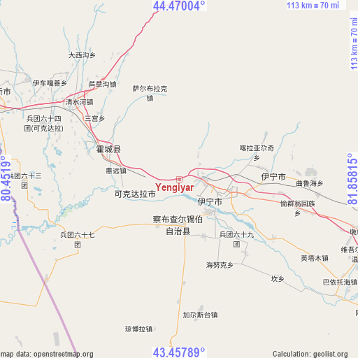
Yengiyar GPS coordinates[2]
43° 57' 58.032" North, 81° 9' 18.072" East
| Map corner | latitude | longitude |
|---|---|---|
| Upper-left | 44.47004°, | 80.4519° |
| Center: | 43.96612°, | 81.15502° |
| Lower-right: | 43.45789°, | 81.85815° |
| Map W x H: | 112.5×112.5 km | = 69.9×69.9mi |
| max Lat: | 53.31946° ⇑7.3% North |
| Yengiyar: | 43.96612° |
| min Lat: | ⇓92.7% South 18.22056° |
| min Long | Yengiyar | max Long |
| 75.07348° | 81.15502° | 134.28917° |
| W 0.7%⇐ | ⇒99.3% E |
Elevation
Elevation of Yengiyar is 652 m = 2139 ft, and this is 167.2 m = 549 ft above average elevation for this country.
| Max E: |
5622 m = 18445 ft | 21% |
| Yengiyar | 652 m 2139 ft | |
| Avg. | 484.8 m = 1591 ft | |
Min E: |
-3 m = -10 ft | 79% |
See also: China elevation on elevation.city.
Geographical zone
Yengiyar is located in North temperate zone (between Tropic of Cancer and the Arctic Circle). Distance of this Northern Tropic circle is 2282.7 km =1418.4 mi to South.| Distance of | km | miles | from Yengiyar |
|---|---|---|---|
| North Pole | 5118.5 | 3180.5 | to North |
| Arctic Circle | 2512.6 | 1561.3 | to North |
| Tropic Cancer | 2282.7 | 1418.4 | to South |
| Equator | 4888.6 | 3037.6 | to South |


Nearby cities:
15 places around Yengiyar: (largest is in red/bold)
• Ailan Mubage
15.6 km =9.7 mi,  114°
114°
• Ayxin Siri
40.1 km =24.9 mi,  235°
235°
• Dadamtu
12.8 km =8 mi,  82°
82°
• Huiyuan
24.4 km =15.2 mi,  267°
267°
• Huocheng
24.6 km =15.3 mi,  293°
293°
• Jagistay
43.5 km =27 mi,  172°
172°
• Kan
45.3 km =28.1 mi,  136°
136°
• Qapqal
19 km =11.8 mi,  196°
196°
• Sadikyüzi
32.4 km =20.1 mi,  97°
97°
• Taxkowrük
14.6 km =9.1 mi,  124°
124°
• Turpanyüzi
26.1 km =16.2 mi, 82°
• Yengitam
47.1 km =29.3 mi, 121°
• Yili
17.3 km =10.7 mi, 115°
• Yining
29.1 km =18.1 mi,  87°
87°
• Yuqunweng
38.7 km =24 mi, 105°
Sources, notices
• [Note1] Compared only with cities in China existing in our database
• [Src1] Map data: © OpenStreetMap contributors (CC-BY-SA)
• [Src2] Other city data from geonames.org with taken over terms of usage.
• [Src3] Geographical zone / Annual Mean Temperature by Robert A. Rohde @ Wikipedia
