Turpanyüzi geodata
Turpanyüzi (Xinjiang) is a seat of a fourth-order administrative division; located in China in Asia/Urumqi (GMT+6) time zone. In our database, there are 1268 cities with bigger population. Compared to other cities in China, 92.7% of cities are located further ↓South; 99.3% of cities are located further →East and 82% of cities have lower elevation than Turpanyüzi. Note1


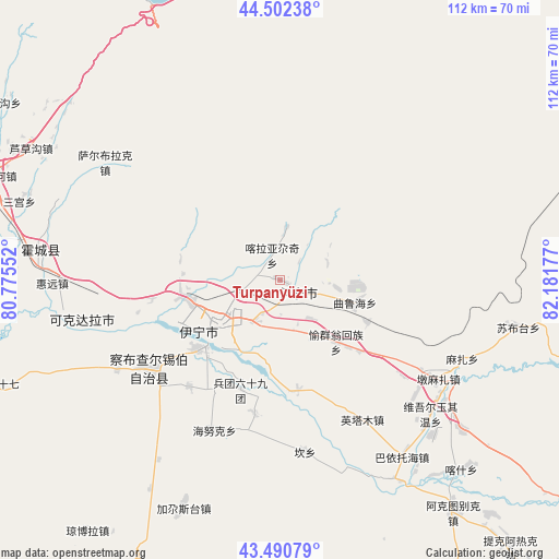
Turpanyüzi GPS coordinates[2]
43° 59' 55.464" North, 81° 28' 43.104" East
| Map corner | latitude | longitude |
|---|---|---|
| Upper-left | 44.50238°, | 80.77552° |
| Center: | 43.99874°, | 81.47864° |
| Lower-right: | 43.49079°, | 82.18177° |
| Map W x H: | 112.5×112.5 km | = 69.9×69.9mi |
| max Lat: | 53.31946° ⇑7.3% North |
| Turpanyüzi: | 43.99874° |
| min Lat: | ⇓92.7% South 18.22056° |
| min Long | Turpanyüzi | max Long |
| 75.07348° | 81.47864° | 134.28917° |
| W 0.7%⇐ | ⇒99.3% E |
Elevation
Elevation of Turpanyüzi is 792 m = 2598 ft, and this is 307.2 m = 1008 ft above average elevation for this country.
| Max E: |
5622 m = 18445 ft | 18% |
| Turpanyüzi | 792 m 2598 ft | |
| Avg. | 484.8 m = 1591 ft | |
Min E: |
-3 m = -10 ft | 82% |
See also: China elevation on elevation.city.
Geographical zone
Turpanyüzi is located in North temperate zone (between Tropic of Cancer and the Arctic Circle). Distance of this Northern Tropic circle is 2286.3 km =1420.6 mi to South.| Distance of | km | miles | from Turpanyüzi |
|---|---|---|---|
| North Pole | 5114.9 | 3178.3 | to North |
| Arctic Circle | 2509 | 1559 | to North |
| Tropic Cancer | 2286.3 | 1420.6 | to South |
| Equator | 4892.2 | 3039.9 | to South |


Nearby cities:
15 places around Turpanyüzi: (largest is in red/bold)
• Ailan Mubage
15.4 km =9.6 mi,  229°
229°
• Dadamtu
13.3 km =8.3 mi,  261°
261°
• Dongmazar
35.1 km =21.8 mi,  121°
121°
• Huiyuan
50.5 km =31.4 mi, 264°
• Huocheng
48.9 km =30.4 mi,  277°
277°
• Kan
36.9 km =22.9 mi,  171°
171°
• Onyar
29.4 km =18.3 mi, 124°
• Qapqal
38.2 km =23.7 mi,  235°
235°
• Sadikyüzi
10 km =6.2 mi,  141°
141°
• Taxkowrük
18.2 km =11.3 mi, 229°
• Yengitam
31.5 km =19.6 mi,  153°
153°
• Yengiyar
26.1 km =16.2 mi, 262°
• Yili
15.1 km =9.4 mi,  223°
223°
• Yining
3.9 km =2.4 mi,  126°
126°
• Yuqunweng
17.9 km =11.1 mi, 140°
Sources, notices
• [Note1] Compared only with cities in China existing in our database
• [Src1] Map data: © OpenStreetMap contributors (CC-BY-SA)
• [Src2] Other city data from geonames.org with taken over terms of usage.
• [Src3] Geographical zone / Annual Mean Temperature by Robert A. Rohde @ Wikipedia
