Huocheng geodata
Huocheng (Xinjiang) is a seat of a third-order administrative division; located in China in Asia/Urumqi (GMT+6) time zone. With population of 360,000 people, there are 162 cities with bigger population in this country. Compared to other cities in China, 92.8% of cities are located further ↓South; 99.4% of cities are located further →East and 78.6% of cities have lower elevation than Huocheng. Note1


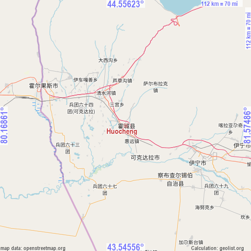
Huocheng GPS coordinates[2]
44° 3' 10.98" North, 80° 52' 18.228" East
| Map corner | latitude | longitude |
|---|---|---|
| Upper-left | 44.55623°, | 80.16861° |
| Center: | 44.05305°, | 80.87173° |
| Lower-right: | 43.54556°, | 81.57486° |
| Map W x H: | 112.4×112.4 km | = 69.8×69.8mi |
| max Lat: | 53.31946° ⇑7.2% North |
| Huocheng: | 44.05305° |
| min Lat: | ⇓92.8% South 18.22056° |
| min Long | Huocheng | max Long |
| 75.07348° | 80.87173° | 134.28917° |
| W 0.6%⇐ | ⇒99.4% E |
Elevation
Elevation of Huocheng is 639 m = 2096 ft, and this is 154.2 m = 506 ft above average elevation for this country.
| Max E: |
5622 m = 18445 ft | 21.4% |
| Huocheng | 639 m 2096 ft | |
| Avg. | 484.8 m = 1591 ft | |
Min E: |
-3 m = -10 ft | 78.6% |
See also: Huocheng elevation on elevation.city.
Geographical zone
Huocheng is located in North temperate zone (between Tropic of Cancer and the Arctic Circle). Distance of this Northern Tropic circle is 2292.3 km =1424.4 mi to South.| Distance of | km | miles | from Huocheng |
|---|---|---|---|
| North Pole | 5108.8 | 3174.5 | to North |
| Arctic Circle | 2502.9 | 1555.2 | to North |
| Tropic Cancer | 2292.3 | 1424.4 | to South |
| Equator | 4898.2 | 3043.6 | to South |


Nearby cities:
15 places around Huocheng: (largest is in red/bold)
• Ailan Mubage
40.3 km =25 mi,  113°
113°
• Ayxin Siri
34.1 km =21.2 mi,  197°
197°
• Dadamtu
36.3 km =22.6 mi,  102°
102°
• Huiyuan
10.8 km =6.7 mi,  189°
189°
• Jagistay
59.9 km =37.2 mi,  151°
151°
• Kan
68.6 km =42.6 mi,  128°
128°
• Qapqal
32.8 km =20.4 mi, 148°
• Qong Bora
57.4 km =35.7 mi,  169°
169°
• Sadikyüzi
56.5 km =35.1 mi, 104°
• Taxkowrük
39.1 km =24.3 mi,  117°
117°
• Turpanyüzi
48.9 km =30.4 mi, 97°
• Yengiyar
24.6 km =15.3 mi, 113°
• Yili
41.9 km =26 mi, 113°
• Yining
52.3 km =32.5 mi, 99°
• Yuqunweng
63.1 km =39.2 mi, 108°
Sources, notices
• [Note1] Compared only with cities in China existing in our database
• [Src1] Map data: © OpenStreetMap contributors (CC-BY-SA)
• [Src2] Other city data from geonames.org with taken over terms of usage.
• [Src3] Geographical zone / Annual Mean Temperature by Robert A. Rohde @ Wikipedia
