Qapqal geodata
Qapqal (Xinjiang) is a seat of a third-order administrative division; located in China in Asia/Urumqi (GMT+6) time zone. With population of 160,000 people, there are 274 cities with bigger population in this country. Compared to other cities in China, 92.5% of cities are located further ↓South; 99.4% of cities are located further →East and 78.6% of cities have lower elevation than Qapqal. Note1


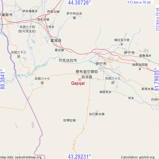
Qapqal GPS coordinates[2]
43° 48' 6.984" North, 81° 5' 13.992" East
| Map corner | latitude | longitude |
|---|---|---|
| Upper-left | 44.30726°, | 80.3841° |
| Center: | 43.80194°, | 81.08722° |
| Lower-right: | 43.29231°, | 81.79035° |
| Map W x H: | 112.9×112.8 km | = 70.2×70.1mi |
| max Lat: | 53.31946° ⇑7.5% North |
| Qapqal: | 43.80194° |
| min Lat: | ⇓92.5% South 18.22056° |
| min Long | Qapqal | max Long |
| 75.07348° | 81.08722° | 134.28917° |
| W 0.6%⇐ | ⇒99.4% E |
Elevation
Elevation of Qapqal is 638 m = 2093 ft, and this is 153.2 m = 503 ft above average elevation for this country.
| Max E: |
5622 m = 18445 ft | 21.4% |
| Qapqal | 638 m 2093 ft | |
| Avg. | 484.8 m = 1591 ft | |
Min E: |
-3 m = -10 ft | 78.6% |
See also: Qapqal elevation on elevation.city.
Geographical zone
Qapqal is located in North temperate zone (between Tropic of Cancer and the Arctic Circle). Distance of this Northern Tropic circle is 2264.4 km =1407 mi to South.| Distance of | km | miles | from Qapqal |
|---|---|---|---|
| North Pole | 5136.7 | 3191.8 | to North |
| Arctic Circle | 2530.9 | 1572.6 | to North |
| Tropic Cancer | 2264.4 | 1407 | to South |
| Equator | 4870.3 | 3026.3 | to South |


Nearby cities:
15 places around Qapqal: (largest is in red/bold)
• Ailan Mubage
23 km =14.3 mi,  58°
58°
• Ayxin Siri
27.9 km =17.3 mi,  260°
260°
• Dadamtu
26.9 km =16.7 mi,  42°
42°
• Huiyuan
25.6 km =15.9 mi,  312°
312°
• Huocheng
32.8 km =20.4 mi,  328°
328°
• Jagistay
27.2 km =16.9 mi,  156°
156°
• Kan
39.5 km =24.5 mi,  111°
111°
• Qong Bora
29.4 km =18.3 mi,  193°
193°
• Sadikyüzi
40.1 km =24.9 mi,  69°
69°
• Taxkowrük
20.2 km =12.6 mi, 60°
• Turpanyüzi
38.2 km =23.7 mi, 55°
• Yengiyar
19 km =11.8 mi,  16°
16°
• Yili
23.7 km =14.7 mi, 62°
• Yining
39.7 km =24.7 mi, 60°
• Yuqunweng
43.5 km =27 mi,  79°
79°
Sources, notices
• [Note1] Compared only with cities in China existing in our database
• [Src1] Map data: © OpenStreetMap contributors (CC-BY-SA)
• [Src2] Other city data from geonames.org with taken over terms of usage.
• [Src3] Geographical zone / Annual Mean Temperature by Robert A. Rohde @ Wikipedia
