Pengdian geodata
Pengdian (Hubei) is a seat of a fourth-order administrative division; located in China in Asia/Shanghai (GMT+8) time zone. In our database, there are 1268 cities with bigger population. Compared to other cities in China, 58.6% of cities are located further ↓South; 50.8% of cities are located further ←West and 55.9% of cities have higher elevation than Pengdian. Note1


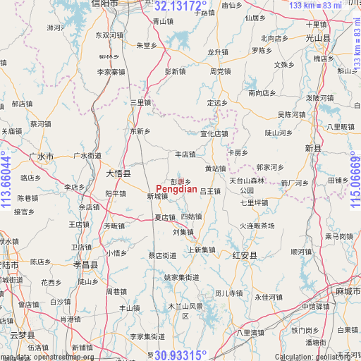
Pengdian GPS coordinates[2]
31° 32' 3.696" North, 114° 21' 48.816" East
| Map corner | latitude | longitude |
|---|---|---|
| Upper-left | 32.13172°, | 113.66044° |
| Center: | 31.53436°, | 114.36356° |
| Lower-right: | 30.93315°, | 115.06669° |
| Map W x H: | 133.3×133.3 km | = 82.8×82.8mi |
| max Lat: | 53.31946° ⇑41.4% North |
| Pengdian: | 31.53436° |
| min Lat: | ⇓58.6% South 18.22056° |
| min Long | Pengdian | max Long |
| 75.07348° | 114.36356° | 134.28917° |
| W 50.8%⇐ | ⇒49.2% E |
Elevation
Elevation of Pengdian is 125 m = 410 ft, and this is 359.8 m = 1180 ft below average elevation for this country.
| Max E: |
5622 m = 18445 ft | 55.9% |
| Avg. | 484.8 m = 1591 ft | |
| Pengdian | 125 m = 410 ft | |
Min E: |
-3 m = -10 ft | 44.1% |
See also: China elevation on elevation.city.
Geographical zone
Pengdian is located in North temperate zone (between Tropic of Cancer and the Arctic Circle). Distance of this Northern Tropic circle is 900.4 km =559.5 mi to South.| Distance of | km | miles | from Pengdian |
|---|---|---|---|
| North Pole | 6500.8 | 4039.4 | to North |
| Arctic Circle | 3894.9 | 2420.2 | to North |
| Tropic Cancer | 900.4 | 559.5 | to South |
| Equator | 3506.3 | 2178.7 | to South |


Nearby cities:
15 places around Pengdian: (largest is in red/bold)
• Dawu Chengguanzhen
24.7 km =15.3 mi,  289°
289°
• Dongxin
23.8 km =14.8 mi,  321°
321°
• Fengdian
10.1 km =6.3 mi,  9°
9°
• Gaodian
14.2 km =8.8 mi,  295°
295°
• Hekou
25 km =15.5 mi,  164°
164°
• Huajiahe
17.7 km =11 mi,  117°
117°
• Huangzhan
13.7 km =8.5 mi,  68°
68°
• Liuji
18.4 km =11.4 mi,  178°
178°
• Luwang
11.1 km =6.9 mi,  106°
106°
• Shangxinji
25.7 km =16 mi, 163°
• Sigu
13.5 km =8.4 mi, 164°
• Xiadian
14.7 km =9.1 mi,  206°
206°
• Xincheng
10.6 km =6.6 mi,  240°
240°
• Xuanhuadian
21.7 km =13.5 mi,  34°
34°
• Yangping
24.3 km =15.1 mi,  260°
260°
Sources, notices
• [Note1] Compared only with cities in China existing in our database
• [Src1] Map data: © OpenStreetMap contributors (CC-BY-SA)
• [Src2] Other city data from geonames.org with taken over terms of usage.
• [Src3] Geographical zone / Annual Mean Temperature by Robert A. Rohde @ Wikipedia
