Gamei geodata
Gamei (Hebei) is a seat of a fourth-order administrative division; located in China in Asia/Urumqi (GMT+6) time zone. In our database, there are 1268 cities with bigger population. Compared to other cities in China, 59.8% of cities are located further ↓South; 96.3% of cities are located further →East and 98.9% of cities have lower elevation than Gamei. Note1


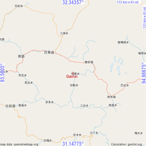
Gamei GPS coordinates[2]
31° 44' 51.324" North, 94° 17' 1.032" East
| Map corner | latitude | longitude |
|---|---|---|
| Upper-left | 32.34357°, | 93.5805° |
| Center: | 31.74759°, | 94.28362° |
| Lower-right: | 31.14775°, | 94.98675° |
| Map W x H: | 133×133 km | = 82.6×82.6mi |
| max Lat: | 53.31946° ⇑40.2% North |
| Gamei: | 31.74759° |
| min Lat: | ⇓59.8% South 18.22056° |
| min Long | Gamei | max Long |
| 75.07348° | 94.28362° | 134.28917° |
| W 3.7%⇐ | ⇒96.3% E |
Elevation
Elevation of Gamei is 4157 m = 13638 ft, and this is 3672.2 m = 12048 ft above average elevation for this country.
| Max E: |
5622 m = 18445 ft | 1.1% |
| Gamei | 4157 m 13638 ft | |
| Avg. | 484.8 m = 1591 ft | |
Min E: |
-3 m = -10 ft | 98.9% |
See also: China elevation on elevation.city.
Geographical zone
Gamei is located in North temperate zone (between Tropic of Cancer and the Arctic Circle). Distance of this Northern Tropic circle is 924.1 km =574.2 mi to South.| Distance of | km | miles | from Gamei |
|---|---|---|---|
| North Pole | 6477.1 | 4024.7 | to North |
| Arctic Circle | 3871.2 | 2405.5 | to North |
| Tropic Cancer | 924.1 | 574.2 | to South |
| Equator | 3530 | 2193.4 | to South |


Nearby cities:
15 places around Gamei: (largest is in red/bold)
• Chiduo
34 km =21.1 mi,  218°
218°
• Dartang
33.8 km =21 mi,  307°
307°
• Jamda
31 km =19.3 mi,  161°
161°
• Jiaqin
11.4 km =7.1 mi,  184°
184°
• Laxi
29.5 km =18.3 mi, 310°
• Nyinmo
55.7 km =34.6 mi,  174°
174°
• Rawa
44.1 km =27.4 mi,  266°
266°
• Rogda
40.7 km =25.3 mi,  259°
259°
• Rongbo
39.3 km =24.4 mi,  122°
122°
• Sechang
45.9 km =28.5 mi,  129°
129°
• Shading
57.9 km =36 mi, 159°
• Xamqu
55.3 km =34.4 mi,  238°
238°
• Yag La
50.7 km =31.5 mi,  288°
288°
• Ya’ngan
18 km =11.2 mi,  53°
53°
• Zaindainxoi
59.4 km =36.9 mi,  281°
281°
Sources, notices
• [Note1] Compared only with cities in China existing in our database
• [Src1] Map data: © OpenStreetMap contributors (CC-BY-SA)
• [Src2] Other city data from geonames.org with taken over terms of usage.
• [Src3] Geographical zone / Annual Mean Temperature by Robert A. Rohde @ Wikipedia
