Dartang geodata
Dartang (Tibet) is a seat of a third-order administrative division; located in China in Asia/Shanghai (GMT+8) time zone. In our database, there are 1268 cities with bigger population. Compared to other cities in China, 60.8% of cities are located further ↓South; 96.4% of cities are located further →East and 98.9% of cities have lower elevation than Dartang. Note1


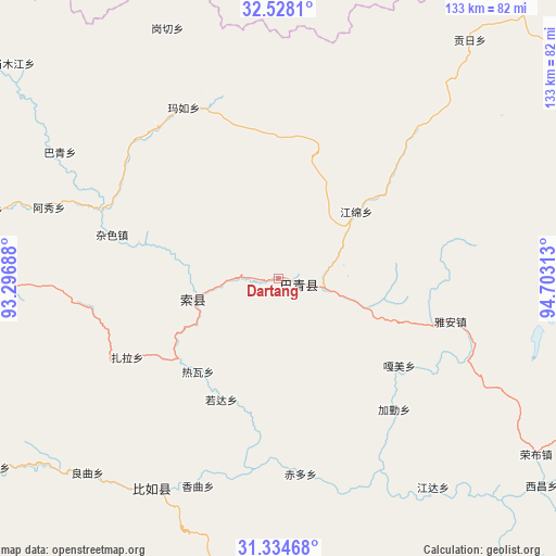
Dartang GPS coordinates[2]
31° 55' 59.988" North, 94° 0' 0" East
| Map corner | latitude | longitude |
|---|---|---|
| Upper-left | 32.5281°, | 93.29688° |
| Center: | 31.93333°, | 94° |
| Lower-right: | 31.33468°, | 94.70313° |
| Map W x H: | 132.7×132.7 km | = 82.5×82.5mi |
| max Lat: | 53.31946° ⇑39.2% North |
| Dartang: | 31.93333° |
| min Lat: | ⇓60.8% South 18.22056° |
| min Long | Dartang | max Long |
| 75.07348° | 94° | 134.28917° |
| W 3.6%⇐ | ⇒96.4% E |
Elevation
Elevation of Dartang is 4138 m = 13576 ft, and this is 3653.2 m = 11986 ft above average elevation for this country.
| Max E: |
5622 m = 18445 ft | 1.1% |
| Dartang | 4138 m 13576 ft | |
| Avg. | 484.8 m = 1591 ft | |
Min E: |
-3 m = -10 ft | 98.9% |
See also: China elevation on elevation.city.
Geographical zone
Dartang is located in North temperate zone (between Tropic of Cancer and the Arctic Circle). Distance of this Northern Tropic circle is 944.7 km =587 mi to South.| Distance of | km | miles | from Dartang |
|---|---|---|---|
| North Pole | 6456.4 | 4011.8 | to North |
| Arctic Circle | 3850.5 | 2392.6 | to North |
| Tropic Cancer | 944.7 | 587 | to South |
| Equator | 3550.7 | 2206.3 | to South |


Nearby cities:
15 places around Dartang: (largest is in red/bold)
• Biru
58.6 km =36.4 mi,  211°
211°
• Biruxong
70.2 km =43.6 mi, 212°
• Chiduo
47.6 km =29.6 mi,  173°
173°
• Gamei
33.8 km =21 mi,  127°
127°
• Jamda
62 km =38.5 mi,  143°
143°
• Jiaqin
41.2 km =25.6 mi, 140°
• Lainqu
64.6 km =40.1 mi,  225°
225°
• Laxi
4.7 km =2.9 mi,  106°
106°
• Rawa
29.1 km =18.1 mi,  216°
216°
• Rogda
31.2 km =19.4 mi,  204°
204°
• Xamqu
53.8 km =33.4 mi, 201°
• Yag La
21.6 km =13.4 mi,  258°
258°
• Ya’ngan
42.5 km =26.4 mi,  103°
103°
• Zaindainxoi
32.8 km =20.4 mi,  253°
253°
• Zala
41.4 km =25.7 mi,  243°
243°
Sources, notices
• [Note1] Compared only with cities in China existing in our database
• [Src1] Map data: © OpenStreetMap contributors (CC-BY-SA)
• [Src2] Other city data from geonames.org with taken over terms of usage.
• [Src3] Geographical zone / Annual Mean Temperature by Robert A. Rohde @ Wikipedia
