Kaji geodata
Kaji (Yunnan) is a seat of a fourth-order administrative division; located in China in Asia/Shanghai (GMT+8) time zone. In our database, there are 1268 cities with bigger population. Compared to other cities in China, 82.3% of cities are located further ↑North; 91.9% of cities are located further →East and 95.3% of cities have lower elevation than Kaji. Note1


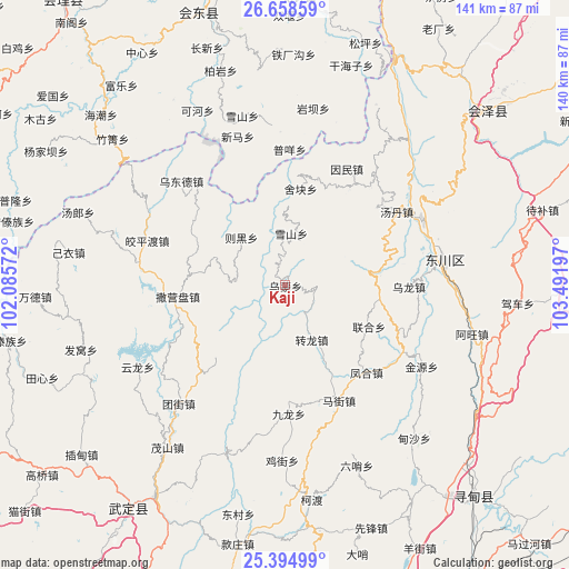
Kaji GPS coordinates[2]
26° 1' 42.564" North, 102° 47' 19.824" East
| Map corner | latitude | longitude |
|---|---|---|
| Upper-left | 26.65859°, | 102.08572° |
| Center: | 26.02849°, | 102.78884° |
| Lower-right: | 25.39499°, | 103.49197° |
| Map W x H: | 140.5×140.5 km | = 87.3×87.3mi |
| max Lat: | 53.31946° ⇑82.3% North |
| Kaji: | 26.02849° |
| min Lat: | ⇓17.7% South 18.22056° |
| min Long | Kaji | max Long |
| 75.07348° | 102.78884° | 134.28917° |
| W 8.1%⇐ | ⇒91.9% E |
Elevation
Elevation of Kaji is 2237 m = 7339 ft, and this is 1752.2 m = 5749 ft above average elevation for this country.
| Max E: |
5622 m = 18445 ft | 4.7% |
| Kaji | 2237 m 7339 ft | |
| Avg. | 484.8 m = 1591 ft | |
Min E: |
-3 m = -10 ft | 95.3% |
See also: China elevation on elevation.city.
Geographical zone
Kaji is located in North temperate zone (between Tropic of Cancer and the Arctic Circle). Distance of this Northern Tropic circle is 288.2 km =179.1 mi to South.| Distance of | km | miles | from Kaji |
|---|---|---|---|
| North Pole | 7113 | 4419.8 | to North |
| Arctic Circle | 4507.1 | 2800.6 | to North |
| Tropic Cancer | 288.2 | 179.1 | to South |
| Equator | 2894.1 | 1798.3 | to South |


Nearby cities:
15 places around Kaji: (largest is in red/bold)
• Chenggan
13.1 km =8.1 mi,  6°
6°
• Dianweijie
15 km =9.3 mi,  154°
154°
• Gangou
64.9 km =40.3 mi,  33°
33°
• Huidong
71 km =44.1 mi,  342°
342°
• Jiaoxiyakou
35.6 km =22.1 mi,  288°
288°
• Jincheng
70.3 km =43.7 mi,  213°
213°
• Jinzhong
64.5 km =40.1 mi,  53°
53°
• Laojie
66.2 km =41.1 mi,  22°
22°
• Laojiezi
26.5 km =16.5 mi,  300°
300°
• Maoshanjie
49.5 km =30.8 mi,  215°
215°
• Muzeng
31 km =19.3 mi,  274°
274°
• Pingshan
64.7 km =40.2 mi, 208°
• Pujiawan
52.6 km =32.7 mi, 289°
• Rende
71.5 km =44.4 mi,  136°
136°
• Xiaopingba
65.5 km =40.7 mi, 205°
Sources, notices
• [Note1] Compared only with cities in China existing in our database
• [Src1] Map data: © OpenStreetMap contributors (CC-BY-SA)
• [Src2] Other city data from geonames.org with taken over terms of usage.
• [Src3] Geographical zone / Annual Mean Temperature by Robert A. Rohde @ Wikipedia
